IMAGES TAKEN NEAR TO
Birch Hall Lane, BARNOLDSWICK, BB18 6JX
Introduction
This page details the photographs taken nearby to Birch Hall Lane, BB18 6JX by members of the Geograph project.
The Geograph project started in 2005 with the aim of publishing, organising and preserving representative images for every square kilometre of Great Britain, Ireland and the Isle of Man.

There are currently over 7.5m images from over14,400 individuals and you can help contribute to the project by visiting https://www.geograph.org.uk
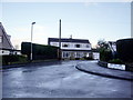
Image Map
Images are licensed for reuse under creativecommons.org/licenses/by-sa/2.0
Notes
- Clicking on the map will re-center to the selected point.
- The higher the marker number, the further away the image location is from the centre of the postcode.
Image Listing (13 Images Found)
Images are licensed for reuse under creativecommons.org/licenses/by-sa/2.0
Image
Details
Distance
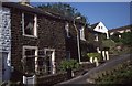
2
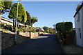
Birch Hall Lane, Earby
A residential street above the youth hostel. This is about a kilometre from the town centre.
Image: © Bill Boaden
Taken: 7 Oct 2011
0.03 miles
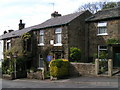
3
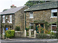
Youth hostel and houses in Earby
Small, stone-built cottages in the town of Earby, one of which was, at the time the photograph was taken, a youth hostel operated by the YHA.
At the time of writing, (August 2017), the hostel is closed, but about to re-open as an independent hostel, in 'late 2017'.
Image: © Trevor Littlewood
Taken: 29 Sep 2004
0.05 miles
4
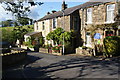
Earby Youth Hostel
Situated a little way out of the town and within range of the Pennine Way. The blue plaque highlights the fact that this was the home of Katharine Bruce Glasier, a founding member of the Independent Labour Party, after her husband had died.
Image: © Bill Boaden
Taken: 7 Oct 2011
0.06 miles
5
Earby Youth Hostel
Earby Youth Hostel pictured here in June 1988. It is the cottage with the street lamp in front of it. It was the home of Katherine Bruce Glasier an English socialist politician, journalist and novelist. She was a founding member of the Independent Labour Party in 1893.
Image: © Philip Halling
Taken: 10 Jun 1988
0.07 miles
6
Earby Youth Hostel
Currently [2005] earmarked for closure as a Youth Hostel (see Image and Image for other Pennine Way hostels in a similar plight). [Update: I'm glad to hear that the hostel was purchased by Pendle Borough Council and leased back to YHA to continue operating, and has an active Friends group.]
Image: © Dave Dunford
Taken: 19 May 2005
0.08 miles
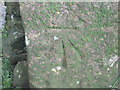
7
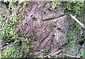
Ordnance Survey Cut Mark
This OS cut mark can be found on the back of the gatepost SE side of track. It marks a point 162.85m above mean sea level.
Image: © Adrian Dust
Taken: 20 Jun 2021
0.13 miles
8
Footpath off Gaylands Lane
It crosses Wentcliff Brook and passes round the east side of Earby.
Image: © Bill Boaden
Taken: 7 Oct 2011
0.14 miles
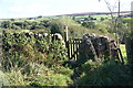
9
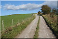
Gaylands Lane
It climbs from Earby to Stone Pit Hill.
Image: © Bill Boaden
Taken: 7 Oct 2011
0.17 miles
10
Ordnance Survey Cut Mark
This mark can be found on a gatepost in Mill Lane.
For more detail see : http://www.bench-marks.org.uk/bm43606
Image: © Peter Wood
Taken: 23 Jun 2012
0.20 miles