IMAGES TAKEN NEAR TO
Coates Avenue, BARNOLDSWICK, BB18 6ES
Introduction
This page details the photographs taken nearby to Coates Avenue, BB18 6ES by members of the Geograph project.
The Geograph project started in 2005 with the aim of publishing, organising and preserving representative images for every square kilometre of Great Britain, Ireland and the Isle of Man.

There are currently over 7.5m images from over14,400 individuals and you can help contribute to the project by visiting https://www.geograph.org.uk
Image Map
Images are licensed for reuse under creativecommons.org/licenses/by-sa/2.0
Notes
- Clicking on the map will re-center to the selected point.
- The higher the marker number, the further away the image location is from the centre of the postcode.
Image Listing (103 Images Found)
Images are licensed for reuse under creativecommons.org/licenses/by-sa/2.0
Image
Details
Distance
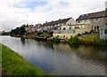
1
Waste ground and house backs, Barnoldswick
Taken from behind Brown's garage on Skipton Road. The houses are in Coates Avenue.
Image: © Dr Neil Clifton
Taken: 12 May 1990
0.01 miles
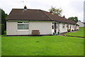
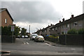
2
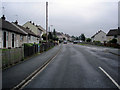
Coates Avenue, Barnoldswick
The Coates estate was built for the former West Riding County Council in the years immediately after World War II, and includes bungalows for the elderly as well as conventional semi-detached houses. Most of the houses are now in private ownership.
Image: © Dr Neil Clifton
Taken: 23 Aug 2006
0.03 miles
3
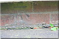
Benchmark on #11 Coates Avenue
Ordnance Survey cut mark benchmark described on the Bench Mark Database at http://www.bench-marks.org.uk/bm69896
Image: © Roger Templeman
Taken: 22 Aug 2015
0.03 miles
4
Bungalows on Coates Avenue
There is an OS benchmark Image on the bricks below the pebbledash on the NW corner of the nearest house
Image: © Roger Templeman
Taken: 22 Aug 2015
0.03 miles
5
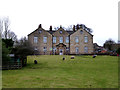
Barnoldswick: Coates Hall
This handsome building probably dates from around 1640. It is now divided into three separate residences,of which the central one is currently For Sale.
Image: © Dr Neil Clifton
Taken: 28 Feb 2012
0.03 miles
6
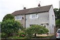
Semi-detached houses on Coates Avenue
Image: © Roger Templeman
Taken: 22 Aug 2015
0.04 miles
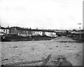
7
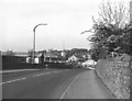
Skipton Road, Barnoldswick
Looking east from the top of the canal bridge. Brown's Garage is seen on the right in the distance - advertising four-star petrol at 43.5 pence per litre.
Image: © Dr Neil Clifton
Taken: 12 May 1990
0.06 miles
8
Barnoldswick: Weets View
These houses were originally built for the former West Riding County Council.
Image: © Dr Neil Clifton
Taken: 2 Aug 2011
0.07 miles
9
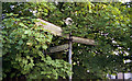
Old West Riding signpost, Barnoldswick
Some eighteen years after the West Riding County Council had gone out of existence, this signpost remained at the junction of Ben Lane and Skipton Road. There were once hundreds if not thousands of similar signs, very helpful to cyclists as they displayed the six-figure grid reference. Most were removed or had their heads cut off, but workmen probably missed this one in the foliage. Some time later I noticed it had gone, but later saw it affixed to someone's house wall - it has now disappeared from there, as well.
Image: © Dr Neil Clifton
Taken: 29 Jul 1992
0.07 miles