IMAGES TAKEN NEAR TO
Lower Rook Street, BARNOLDSWICK, BB18 6AD
Introduction
This page details the photographs taken nearby to Lower Rook Street, BB18 6AD by members of the Geograph project.
The Geograph project started in 2005 with the aim of publishing, organising and preserving representative images for every square kilometre of Great Britain, Ireland and the Isle of Man.

There are currently over 7.5m images from over14,400 individuals and you can help contribute to the project by visiting https://www.geograph.org.uk
Image Map
Images are licensed for reuse under creativecommons.org/licenses/by-sa/2.0
Notes
- Clicking on the map will re-center to the selected point.
- The higher the marker number, the further away the image location is from the centre of the postcode.
Image Listing (269 Images Found)
Images are licensed for reuse under creativecommons.org/licenses/by-sa/2.0
Image
Details
Distance
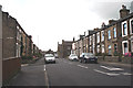
1
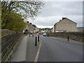
Barnoldswick: Rook Street
Looking northeast, this shows the top of the former railway bridge.
Image: © Dr Neil Clifton
Taken: 4 May 2012
0.01 miles
2
Barnoldswick: Rook Street
Showing the top of the bridge which carried the street over the now-dismantled railway
Image: © Dr Neil Clifton
Taken: 8 Aug 2012
0.03 miles
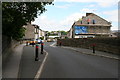
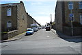
3
Barnoldswick: Fountain Street
Looking northwest from Rook Street.
Image: © Dr Neil Clifton
Taken: 4 May 2012
0.03 miles
4

Barnoldswick: Allotments
Looking southeast from the top of the Rook Street bridge, these allotments occupy part of the course of the former Barnoldswick branch railway
Image: © Dr Neil Clifton
Taken: 4 May 2012
0.03 miles
5

Barnoldswick: Steps
These lead up from the overflow car park to Rook Street.
Image: © Dr Neil Clifton
Taken: 4 May 2012
0.04 miles
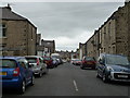
7
Barnoldswick: Rook Street
Looking towards Essex Street
Image: © Dr Neil Clifton
Taken: 8 Aug 2012
0.05 miles
9
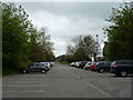
Barnoldswick: Overflow Co-op Car Park
This car park is behind the Co-op, but on the far side of Rainhall Road. It is on what was the course of the former Barnoldswick branch railway.
Image: © Dr Neil Clifton
Taken: 4 May 2012
0.06 miles
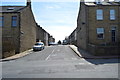
10
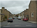
Barnoldswick: Harrison Street
Looking southeast from Rook Street
Image: © Dr Neil Clifton
Taken: 4 May 2012
0.06 miles