IMAGES TAKEN NEAR TO
Back Smith Street, BARNOLDSWICK, BB18 5QL
Introduction
This page details the photographs taken nearby to Back Smith Street, BB18 5QL by members of the Geograph project.
The Geograph project started in 2005 with the aim of publishing, organising and preserving representative images for every square kilometre of Great Britain, Ireland and the Isle of Man.

There are currently over 7.5m images from over14,400 individuals and you can help contribute to the project by visiting https://www.geograph.org.uk
Image Map (Loading...)


Getting Data...Please wait
Leaflet Map data © OpenStreetMap
Images are licensed for reuse under creativecommons.org/licenses/by-sa/2.0
Notes
- Clicking on the map will re-center to the selected point.
- The higher the marker number, the further away the image location is from the centre of the postcode.
Image Listing (201 Images Found)
Images are licensed for reuse under creativecommons.org/licenses/by-sa/2.0
Image
Details
Distance
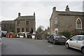
1
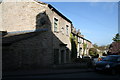
Barnoldswick: 16 Townhead
An inscription on the front of the house reads: 'Barnoldswick Friendly Society 1829'.
Image: © Dr Neil Clifton
Taken: 10 Apr 2011
0.05 miles
2
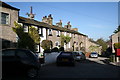
Barnoldswick: 18-26 (evens), Townhead
These five houses bear the numbers shown, after which come 34 and 36. Confused? You should be!
Image: © Dr Neil Clifton
Taken: 10 Apr 2011
0.05 miles
3
Barnoldswick: House number 9
Boldly displayed on the door: '9'. But 9 what? 9 Townhead is the only reasonable conclusion. The next house does not have a '7' (or any other number) on display, and according to the 1:2500 OS plan, it is no 40!
Image: © Dr Neil Clifton
Taken: 10 Apr 2011
0.05 miles
4
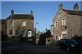
Barnoldswick: Town Head
The term 'Town Head' refers to a hamlet or district, as well as to a street, as although even-numbered houses in 'Townhead' lie along a recognisable line, the odd-numbered houses seem to be scattered in various places.
Image: © Dr Neil Clifton
Taken: 10 Apr 2011
0.05 miles
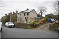
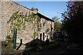
5
Another house being done up
This one is at the end of Esp Lane, which has quite a few older buildings.
Image: © Bill Boaden
Taken: 3 Dec 2016
0.05 miles
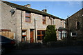
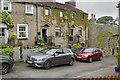
6
A house being done up
The house on Colne Road is being extended.
Image: © Bill Boaden
Taken: 3 Dec 2016
0.06 miles
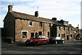
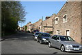
7
Town Head Barnoldswick
This is a small row of three storey terraced cottages, of some age, near the present edge of Barnoldswick.
Image: © Malcolm Neal
Taken: 15 Jul 2017
0.06 miles
8
Barnoldswick: 20 to 32 Westgate
There is a gap in the sequence of even numbered houses along here. Possibly the missing numbers were cellar-dwellings?
Image: © Dr Neil Clifton
Taken: 10 Apr 2011
0.06 miles
10
Barnoldswick: Westgate
Looking west. The fact that old street names end in '-gate', and the ending '-wick' in the name of the town itself, testify to Barnoldswick having been part of the Danelaw: hence it should be regarded as part of Yorkshire, in spite of having been placed administratively under Lancashire County Council in 1974.
Image: © Dr Neil Clifton
Taken: 10 Apr 2011
0.07 miles