IMAGES TAKEN NEAR TO
Cedars Close, BARNOLDSWICK, BB18 5PP
Introduction
This page details the photographs taken nearby to Cedars Close, BB18 5PP by members of the Geograph project.
The Geograph project started in 2005 with the aim of publishing, organising and preserving representative images for every square kilometre of Great Britain, Ireland and the Isle of Man.

There are currently over 7.5m images from over14,400 individuals and you can help contribute to the project by visiting https://www.geograph.org.uk
Image Map (Loading...)


Getting Data...Please wait
Leaflet Map data © OpenStreetMap
Images are licensed for reuse under creativecommons.org/licenses/by-sa/2.0
Notes
- Clicking on the map will re-center to the selected point.
- The higher the marker number, the further away the image location is from the centre of the postcode.
Image Listing (166 Images Found)
Images are licensed for reuse under creativecommons.org/licenses/by-sa/2.0
Image
Details
Distance
1
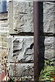
Benchmark on #37 Colne Road
Ordnance Survey cut mark benchmark described on the Bench Mark Database at http://www.bench-marks.org.uk/bm70021
Image: © Roger Templeman
Taken: 29 Aug 2015
0.02 miles
2
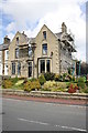
#37 Colne Road
There is an OS benchmark Image on the right hand side of the house at the front corner
Image: © Roger Templeman
Taken: 29 Aug 2015
0.03 miles
3
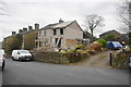
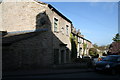
A house being done up
The house on Colne Road is being extended.
Image: © Bill Boaden
Taken: 3 Dec 2016
0.03 miles
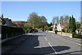
4

Colne Road in Barnoldswick
Following the Barnoldswick History Walk.
Image: © steven ruffles
Taken: 3 May 2025
0.05 miles
6
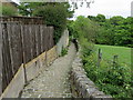
Longfield Lane, Barnoldswick
Longfield Lane isn't really a lane - it is a very old (some say ancient) paved footpath.
Image: © Dr Neil Clifton
Taken: Unknown
0.08 miles
7
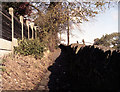
Pendle Way, Barnoldswick
The long distance footpath follows a cobbled way towards Crow Foot Row, on the outskirts of Barnoldswick.
Image: © Chris Heaton
Taken: 25 May 2011
0.08 miles
8
Barnoldswick: 16 Townhead
An inscription on the front of the house reads: 'Barnoldswick Friendly Society 1829'.
Image: © Dr Neil Clifton
Taken: 10 Apr 2011
0.08 miles
9
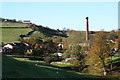
Looking towards Bancroft Mill
Bancroft Mill was the last of Barnoldswick's cotton mills to be built, in the early part of the 20th century. When it closed, it was demolished but the engine house and chimney were retained as Bancroft Steam Museum, and on some Sundays in the summer, the engine is set in motion and the public are admitted to view it. The photograph was taken from Manchester Road.
Image: © Dr Neil Clifton
Taken: 30 Oct 2007
0.09 miles
10
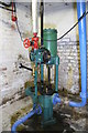
Weir pump, Bancroft Mill
This is in the engine house basement and was one of the boiler feed pumps. This type of non-rotative feed pump was once ubiquitous and was made until relatively recent times. This one was by G & J Weir of Cathcart, Glasgow.
Image: © Chris Allen
Taken: 7 Jun 2009
0.09 miles