IMAGES TAKEN NEAR TO
Monks Cottages, BARNOLDSWICK, BB18 5PA
Introduction
This page details the photographs taken nearby to Monks Cottages, BB18 5PA by members of the Geograph project.
The Geograph project started in 2005 with the aim of publishing, organising and preserving representative images for every square kilometre of Great Britain, Ireland and the Isle of Man.

There are currently over 7.5m images from over14,400 individuals and you can help contribute to the project by visiting https://www.geograph.org.uk
Image Map (Loading...)


Getting Data...Please wait
Leaflet Map data © OpenStreetMap
Images are licensed for reuse under creativecommons.org/licenses/by-sa/2.0
Notes
- Clicking on the map will re-center to the selected point.
- The higher the marker number, the further away the image location is from the centre of the postcode.
Image Listing (416 Images Found)
Images are licensed for reuse under creativecommons.org/licenses/by-sa/2.0
Image
Details
Distance

3
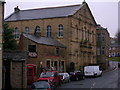
Barnoldswick Independent Methodist Chapel, 1892
Image: © John H Darch
Taken: 11 Feb 2011
0.02 miles

7
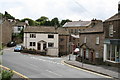
Barnoldswick Bethesda Street
Houses on the right numbered 1 to 8 consecutively
Image: © Dr Neil Clifton
Taken: 3 May 2015
0.02 miles
8
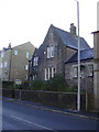
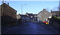
"The Old Police Station" Manchester Road
Originally a West Riding station it became part of The Lancashire Constabulary after local government reorganisation in April 1974, a new station was built and this is now a house
Image: © Robert Wade
Taken: 9 Nov 2009
0.02 miles
9
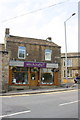
'whichcrafts?', #32 Church Street
There is an OS benchmark Image on the front of the shop at the right hand corner
Image: © Roger Templeman
Taken: 22 Aug 2015
0.03 miles
10
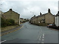
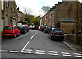
Bottom of Manchester Road, Barnoldswick, Yorkshire
This shows the road junction at the south-western end of Church Street. The road round to the left becomes Manchester Road at this point, and until the 1930s when the B6383 was constructed, it was the main route into Lancashire. The two white semi-detached stone roofed cottages are in fact Nos. 1 and 3, Manchester Road.
The much smaller road down to the right is Walmsgate, with the Independent Methodist church about fifty yards further on. The two cottages next to the shop are Nos 36 and 34, Church Street.
Image: © Dr Neil Clifton
Taken: 7 Jul 2007
0.03 miles