IMAGES TAKEN NEAR TO
Gisburn Road, BARNOLDSWICK, BB18 5HA
Introduction
This page details the photographs taken nearby to Gisburn Road, BB18 5HA by members of the Geograph project.
The Geograph project started in 2005 with the aim of publishing, organising and preserving representative images for every square kilometre of Great Britain, Ireland and the Isle of Man.

There are currently over 7.5m images from over14,400 individuals and you can help contribute to the project by visiting https://www.geograph.org.uk
Image Map
Images are licensed for reuse under creativecommons.org/licenses/by-sa/2.0
Notes
- Clicking on the map will re-center to the selected point.
- The higher the marker number, the further away the image location is from the centre of the postcode.
Image Listing (207 Images Found)
Images are licensed for reuse under creativecommons.org/licenses/by-sa/2.0
Image
Details
Distance
1
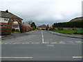
Barnoldswick: Glenthorne Avenue
From Gisburn Road
Image: © Dr Neil Clifton
Taken: 8 Apr 2012
0.01 miles
2
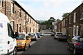
Edmondson Street, Barnoldswick, Yorkshire
Edmondson Street is believed to be named for Thomas Edmondson, the inventor of the well-known printed card type of railway ticket which was universally used on the railways of Britain until modern times. The street runs off Gisburn Road in a north-easterly direction and this photograph is looking towards the far end, where it meets Colin Street and Chapman Court.
Image: © Dr Neil Clifton
Taken: 8 Jul 2007
0.01 miles
3
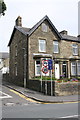
'Ashlea' at Edmondson Street / Gisburn Road junction
There is an OS benchmark Image on the wall corner, right hand face
Image: © Roger Templeman
Taken: 22 Aug 2015
0.02 miles
4
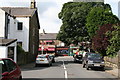
Gisburn Road from Edmondson Street, Barnoldswick
Looking from the mouth of Edmondson Street where Bolland Street joins gives a view of some of the shops on the Gisburn Road shopping parade. On the right the Post Office is seen, with, next to it, Brown's butcher's shop. On the left of that is Mario's Italian restaurant.
Image: © Dr Neil Clifton
Taken: 8 Jul 2007
0.02 miles
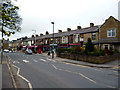
5

Gisburn Road, Barnoldswick (1)
Seen in 1990, looking towards the centre of the town.
Image: © Dr Neil Clifton
Taken: 12 May 1990
0.03 miles
6
Shops on Gisburn Road, Barnoldswick
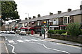
Gisburn Road (B6251) joins Barnoldswick with the A59 at Yarlside. This photograph is taken looking south-eastwards towards Barnoldswick. Some of the shop premises here have reverted to use as dwelling houses, but those that remain fulfil an important local function. From the right hand end there is a newsagent, then a vacant shop, then a post office and a butcher. The next two shops have been converted into an Italian restaurant, while a mini-mart is just beyond that. At the end of the parade is the junction with Harper Street, on the right hand side.
Image: © Dr Neil Clifton
Taken: 7 Jul 2007
0.03 miles
7
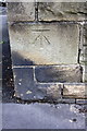
Benchmark on wall outside #46 Gisburn Road
Ordnance Survey cut mark benchmark described on the Bench Mark Database at http://www.bench-marks.org.uk/bm47582
Image: © Roger Templeman
Taken: 22 Aug 2015
0.03 miles
8
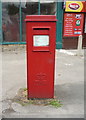
Elizabeth II postbox on Gisburn Road, Barnoldswick
Postbox No. BB18 364.
See Image] for context.
Image: © JThomas
Taken: 2 Aug 2018
0.03 miles
9
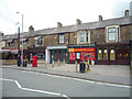
Shops on Gisburn Road, Barnoldswick
Showing position of Postbox No. BB18 364.
See Image] for postbox.
Image: © JThomas
Taken: 2 Aug 2018
0.03 miles
10
Barnoldswick: Gisburn Road shops
A few years ago, this row consisted entirely of shops; the one nearest the camera, which had been a greengrocer's shop, was the first to go. Now two of the others have been made into an Italian restaurant, and others are dwelling houses. A Post Office lasted until quite recently, but has now followed the others into oblivion. Just a few remain as shops.
Image: © Dr Neil Clifton
Taken: 8 Apr 2012
0.04 miles