IMAGES TAKEN NEAR TO
Park Road, BARNOLDSWICK, BB18 5BF
Introduction
This page details the photographs taken nearby to Park Road, BB18 5BF by members of the Geograph project.
The Geograph project started in 2005 with the aim of publishing, organising and preserving representative images for every square kilometre of Great Britain, Ireland and the Isle of Man.

There are currently over 7.5m images from over14,400 individuals and you can help contribute to the project by visiting https://www.geograph.org.uk
Image Map
Images are licensed for reuse under creativecommons.org/licenses/by-sa/2.0
Notes
- Clicking on the map will re-center to the selected point.
- The higher the marker number, the further away the image location is from the centre of the postcode.
Image Listing (416 Images Found)
Images are licensed for reuse under creativecommons.org/licenses/by-sa/2.0
Image
Details
Distance
3
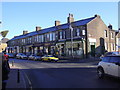
Barnoldswick: Park Road
From Rainhall Road
Image: © Dr Neil Clifton
Taken: 20 Aug 2012
0.02 miles
4
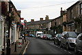
Rainhall Road - viewed from Frank Street
Image: © Betty Longbottom
Taken: 30 Jul 2016
0.02 miles
7
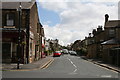
Park Road, Barnoldswick, Yorkshire
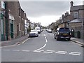
This is a very long road and runs from the Town Centre out to the south-east then curving round to meet the main road out of Town, the B6383 Kelbrook Road. The housing changes along the road from terrace properties at this end, to semi-detached at the far end. Along the road, beyond the red car on the left hand side, is a fish and chip shop - its sign can just be made out. We are looking from Rainhall road here, and the doctor's surgery is just on the right at this end of Park Road.
Image: © Dr Neil Clifton
Taken: 7 Jul 2007
0.02 miles
8
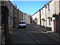
King Street, Barnoldswick
Taken from the junction of King Street with the southern end of Newtown. King Street runs roughly westwards from here to a junction with Jepp Hill, by the former Town Hall. Even numbers on the right, 2 to 12. Odd numbers left, 1 to 11, then Ridge Street, then to 21.
Image: © Dr Neil Clifton
Taken: 10 Sep 2007
0.02 miles
9

Rainhall Road - viewed from Frank Street
Image: © Betty Longbottom
Taken: 30 Jul 2016
0.02 miles
10
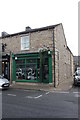
Spektra Gallery at Rainhall Road / York Street junction
See http://www.bench-marks.org.uk/bm57387
Image: © Roger Templeman
Taken: 29 Aug 2015
0.02 miles