IMAGES TAKEN NEAR TO
Lower Philips Road, BLACKBURN, BB1 5UD
Introduction
This page details the photographs taken nearby to Lower Philips Road, BB1 5UD by members of the Geograph project.
The Geograph project started in 2005 with the aim of publishing, organising and preserving representative images for every square kilometre of Great Britain, Ireland and the Isle of Man.

There are currently over 7.5m images from over14,400 individuals and you can help contribute to the project by visiting https://www.geograph.org.uk
Image Map (Loading...)


Getting Data...Please wait
Leaflet Map data © OpenStreetMap
Images are licensed for reuse under creativecommons.org/licenses/by-sa/2.0
Notes
- Clicking on the map will re-center to the selected point.
- The higher the marker number, the further away the image location is from the centre of the postcode.
Image Listing (8 Images Found)
Images are licensed for reuse under creativecommons.org/licenses/by-sa/2.0
Image
Details
Distance
1
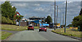
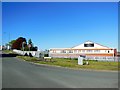
Philips Road, Blackburn
There was a Phillips site on the right (two "l"s) and I was tempted to get it in to play on the spelling, but this is a nice busy shot.
Image: © Ian Greig
Taken: 9 Jul 2015
0.05 miles
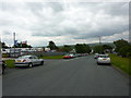
5
Wish Homes building
On Philips Road, Little Harwood, Blackburn.
Image: © Ian S
Taken: 23 May 2015
0.21 miles
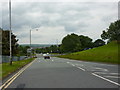
6
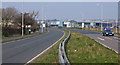
Barrier Snake
This is the A6119 Blackburn 'Ring Road'. The picture is taken from the crossing that leads to the new (2006) retail area containing car and motorbike showrooms.
Image: © Mr T
Taken: 28 Mar 2007
0.23 miles
7
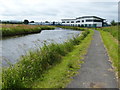
Leeds and Liverpool Canal on the edge of Blackburn
The buildings are part of the Whitebirk Industrial Estate.
Image: © Mat Fascione
Taken: 17 Jul 2016
0.24 miles
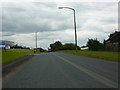
8
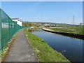
Bend in the Leeds and Liverpool Canal
Looking north on National cycle route 6.
Image: © JThomas
Taken: 19 Apr 2019
0.25 miles