IMAGES TAKEN NEAR TO
Challenge Way, BLACKBURN, BB1 5FE
Introduction
This page details the photographs taken nearby to Challenge Way, BB1 5FE by members of the Geograph project.
The Geograph project started in 2005 with the aim of publishing, organising and preserving representative images for every square kilometre of Great Britain, Ireland and the Isle of Man.

There are currently over 7.5m images from over14,400 individuals and you can help contribute to the project by visiting https://www.geograph.org.uk
Image Map (Loading...)


Getting Data...Please wait
Leaflet Map data © OpenStreetMap
Images are licensed for reuse under creativecommons.org/licenses/by-sa/2.0
Notes
- Clicking on the map will re-center to the selected point.
- The higher the marker number, the further away the image location is from the centre of the postcode.
Image Listing (19 Images Found)
Images are licensed for reuse under creativecommons.org/licenses/by-sa/2.0
Image
Details
Distance
1
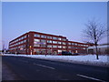
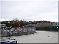
Part of The Glenfield Business Park Centre
Image: © Alexander P Kapp
Taken: 8 Jan 2010
0.02 miles
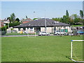
2
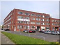
Glenfield Park Business Centre
Housed in an art deco former cotton mill.
Image: © John H Darch
Taken: 28 Apr 2014
0.02 miles
8
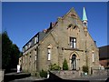
Benson Street Wesleyan Methodist Blackburn
The building was originally a Wesleyan Methodist Chapel, it closed and has been converted to living accommodation.
Image: © Steve Houldsworth
Taken: Unknown
0.15 miles
9
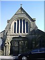
Parish Church of St Stephens, Little Harwood
Image: © Alexander P Kapp
Taken: 1 May 2007
0.15 miles
10
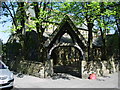
Lych gate, Parish Church of St Stephens,Little Harwood
Image: © Alexander P Kapp
Taken: 1 May 2007
0.16 miles