IMAGES TAKEN NEAR TO
Bridgewater Drive, BLACKBURN, BB1 5AJ
Introduction
This page details the photographs taken nearby to Bridgewater Drive, BB1 5AJ by members of the Geograph project.
The Geograph project started in 2005 with the aim of publishing, organising and preserving representative images for every square kilometre of Great Britain, Ireland and the Isle of Man.

There are currently over 7.5m images from over14,400 individuals and you can help contribute to the project by visiting https://www.geograph.org.uk
Image Map
Images are licensed for reuse under creativecommons.org/licenses/by-sa/2.0
Notes
- Clicking on the map will re-center to the selected point.
- The higher the marker number, the further away the image location is from the centre of the postcode.
Image Listing (31 Images Found)
Images are licensed for reuse under creativecommons.org/licenses/by-sa/2.0
Image
Details
Distance
1
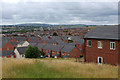
A View towards Bastwell
New housing estate build, as seen from Clarendon Road in the northern enclaves of Blackburn.
Image: © Chris Heaton
Taken: 20 Jul 2017
0.02 miles
2

Railway bridge over Laburnum Road
Gated to prevent access.
Image: © JThomas
Taken: 19 Apr 2019
0.08 miles

4
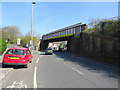
Railway bridge over Whalley New Road (A666)
Image: © JThomas
Taken: 19 Apr 2019
0.09 miles
5

Whalley New Road, Blackburn
The A666 executes a double bend under a railway bridge that carries the line from Clitheroe.
Image: © Chris Heaton
Taken: 20 Jul 2017
0.10 miles
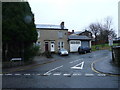
6

Skew Bridge, Blackburn
The line from Blackburn to Clitheroe makes the A666 do an awkward wriggle.
Image: © Mike and Kirsty Grundy
Taken: 1 Aug 2005
0.10 miles
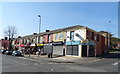
9
Hawthorne Street Methodist Blackburn
Located at the junction of Hawthorne Street with Cedar Street Blackburn still open when this image was taken.
Image: © Steve Houldsworth
Taken: Unknown
0.13 miles
10
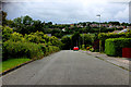
Rosewood Avenue
What is now Rosewood Avenue was originally called Teak Street before the council estate was built. The houses pictured were the only ones in Teak Street.
The nearby allotments Image get their name from this street.
Image: © Tony Mercer
Taken: 19 Jan 2009
0.13 miles