IMAGES TAKEN NEAR TO
Peronne Crescent, BLACKBURN, BB1 3NS
Introduction
This page details the photographs taken nearby to Peronne Crescent, BB1 3NS by members of the Geograph project.
The Geograph project started in 2005 with the aim of publishing, organising and preserving representative images for every square kilometre of Great Britain, Ireland and the Isle of Man.

There are currently over 7.5m images from over14,400 individuals and you can help contribute to the project by visiting https://www.geograph.org.uk
Image Map
Images are licensed for reuse under creativecommons.org/licenses/by-sa/2.0
Notes
- Clicking on the map will re-center to the selected point.
- The higher the marker number, the further away the image location is from the centre of the postcode.
Image Listing (17 Images Found)
Images are licensed for reuse under creativecommons.org/licenses/by-sa/2.0
Image
Details
Distance
1
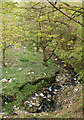
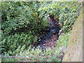
Knuzden Brook
Unfortunately, as is often the case in urban areas, the brook does seem to be a magnet for litter.
Image: © Mr T
Taken: 21 Apr 2007
0.07 miles
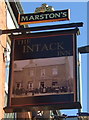
3
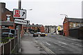
Five-way junction at Intack
The main route is Accrington Road, the A679, which crosses at right angles ahead.
Image: © Bill Boaden
Taken: 23 Apr 2011
0.09 miles
5
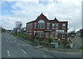
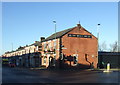
Intack and Knuzden Conservative Club
Image: © Raymond Knapman
Taken: 7 Mar 2014
0.09 miles
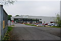
8
They've started work here on The Weaver's Wheel
A strategic cycle network www.bwdconnect.org.uk/weavers-wheel
Image: © Ian Greig
Taken: 16 Sep 2016
0.11 miles
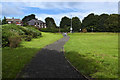
9
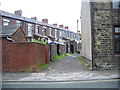
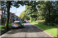
Back street, Intack
Runs, parallel with St Ives Street
Image: © Alexander P Kapp
Taken: 27 May 2008
0.12 miles
10
Knuzden Brook, Abbott Clough
Looking down into the deep, wooded valley on the outskirts of Blackburn
Image: © David Dixon
Taken: 12 Sep 2020
0.12 miles