IMAGES TAKEN NEAR TO
Whitebirk Road, BLACKBURN, BB1 3HY
Introduction
This page details the photographs taken nearby to Whitebirk Road, BB1 3HY by members of the Geograph project.
The Geograph project started in 2005 with the aim of publishing, organising and preserving representative images for every square kilometre of Great Britain, Ireland and the Isle of Man.

There are currently over 7.5m images from over14,400 individuals and you can help contribute to the project by visiting https://www.geograph.org.uk
Image Map
Images are licensed for reuse under creativecommons.org/licenses/by-sa/2.0
Notes
- Clicking on the map will re-center to the selected point.
- The higher the marker number, the further away the image location is from the centre of the postcode.
Image Listing (18 Images Found)
Images are licensed for reuse under creativecommons.org/licenses/by-sa/2.0
Image
Details
Distance
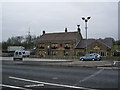
1
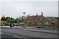
The Red Lion, Whitebirk
Stated as best food pub but it doesn't say how wide an area. This is an outpost of J W Lees in strong Thwaites territory.
Image: © Bill Boaden
Taken: 23 Apr 2011
0.14 miles
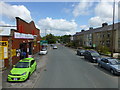
3
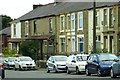
The Red Lion, Whitebirk Road, Blackburn
Image: © Alexander P Kapp
Taken: 25 Apr 2008
0.16 miles
4
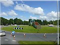
Approach to Greenbank Bridge at Oswaldwistle
Viewed from Burnley Road
Image: © Raymond Knapman
Taken: 30 Jul 2015
0.16 miles
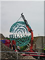
5
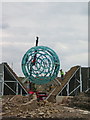
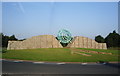
Altogether now
Ongoing work on the new sculpture at Whitebirk.
Image: © Alexander P Kapp
Taken: 24 Jun 2008
0.19 miles
6
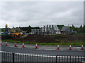
Construction of a new sculpture for the people of Blackburn
Image: © Alexander P Kapp
Taken: 27 May 2008
0.20 miles
8
Almost there
Ongoing work on the new sculpture at Whitebirk.
Image: © Alexander P Kapp
Taken: 24 Jun 2008
0.20 miles