
IMAGES TAKEN NEAR TO
Sough Lane, BLACKBURN, BB1 2PJ
Introduction
This page details the photographs taken nearby to Sough Lane, BB1 2PJ by members of the Geograph project.
The Geograph project started in 2005 with the aim of publishing, organising and preserving representative images for every square kilometre of Great Britain, Ireland and the Isle of Man.

There are currently over 7.5m images from over14,400 individuals and you can help contribute to the project by visiting https://www.geograph.org.uk
Image Map
Images are licensed for reuse under creativecommons.org/licenses/by-sa/2.0
Notes
- Clicking on the map will re-center to the selected point.
- The higher the marker number, the further away the image location is from the centre of the postcode.
Image Listing (7 Images Found)
Images are licensed for reuse under creativecommons.org/licenses/by-sa/2.0
Image
Details
Distance
1
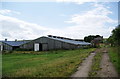
New barns and a ruined farmhouse
This is alongside South Lane. The barns are empty and getting an airing, making a bit of a smell in the atmosphere.
Image: © Bill Boaden
Taken: 3 Jul 2010
0.05 miles
2

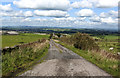
Blackburn Landscape
View from the B6232, Blackburn to Haslingden Road, looking towards Oswaldtwistle and Accrington. In the centre of the picture is Pendle Hill. Refer to picture Image for a close view.
Image: © Len Williams
Taken: 11 Jan 2014
0.13 miles
5
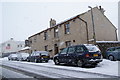
The Pack Horse, Belthorn
Most of Belthorn is off the main road; this is a small enclave on the main road known as the Grane Road. Matthew Brown was a small brewery swallowed up by Thwaites.
Image: © Bill Boaden
Taken: 21 Feb 2010
0.22 miles
6
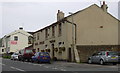
Pack Horse Elton Road Belthorn
On the B6232 between Guide and Haslingden
Image: © Robert Wade
Taken: 24 Jun 2007
0.24 miles
7
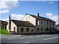
The Pack Horse, Elton Road, Belthorn
Image: © Alexander P Kapp
Taken: 9 Sep 2007
0.24 miles