IMAGES TAKEN NEAR TO
Sett End Road North, BLACKBURN, BB1 2NW
Introduction
This page details the photographs taken nearby to Sett End Road North, BB1 2NW by members of the Geograph project.
The Geograph project started in 2005 with the aim of publishing, organising and preserving representative images for every square kilometre of Great Britain, Ireland and the Isle of Man.

There are currently over 7.5m images from over14,400 individuals and you can help contribute to the project by visiting https://www.geograph.org.uk
Image Map
Images are licensed for reuse under creativecommons.org/licenses/by-sa/2.0
Notes
- Clicking on the map will re-center to the selected point.
- The higher the marker number, the further away the image location is from the centre of the postcode.
Image Listing (6 Images Found)
Images are licensed for reuse under creativecommons.org/licenses/by-sa/2.0
Image
Details
Distance
1
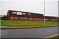
Twinkle Toes Nursery
This is on Shadsworth Business Park and looks much like the other units.
Image: © Bill Boaden
Taken: 12 Jan 2011
0.06 miles
2
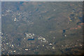
Blackburn : Blackburn Aerial Scenery
Looking down towards Blackburn and the countryside surrounding it.
Image: © Lewis Clarke
Taken: 5 Jan 2017
0.10 miles
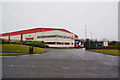
3

Partnership Way
One of the roads on Shadsworth Business Park.
Image: © Bill Boaden
Taken: 12 Jan 2011
0.11 miles
4
Thwaites Brewery Distribution Centre
Whilst the brewery is in the centre of the town, this unit on Shadsworth Business Park deals with the supply to the numerous outlets in the Thwaites empire.
Image: © Bill Boaden
Taken: 12 Jan 2011
0.15 miles
6
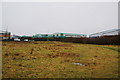
Open space next to Shadsworth Business Park
This is seen from the Arran Trail which follows the route of Knuzden Brook at this point. Gap occupy several units in the business park.
Image: © Bill Boaden
Taken: 12 Jan 2011
0.24 miles