IMAGES TAKEN NEAR TO
St. Oswalds Close, BLACKBURN, BB1 2BY
Introduction
This page details the photographs taken nearby to St. Oswalds Close, BB1 2BY by members of the Geograph project.
The Geograph project started in 2005 with the aim of publishing, organising and preserving representative images for every square kilometre of Great Britain, Ireland and the Isle of Man.

There are currently over 7.5m images from over14,400 individuals and you can help contribute to the project by visiting https://www.geograph.org.uk
Image Map (Loading...)


Getting Data...Please wait
Leaflet Map data © OpenStreetMap
Images are licensed for reuse under creativecommons.org/licenses/by-sa/2.0
Notes
- Clicking on the map will re-center to the selected point.
- The higher the marker number, the further away the image location is from the centre of the postcode.
Image Listing (12 Images Found)
Images are licensed for reuse under creativecommons.org/licenses/by-sa/2.0
Image
Details
Distance
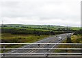
3
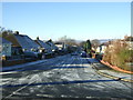
Lyndhurst Avenue
Looking west on a frosty morning.
Image: © JThomas
Taken: 26 Nov 2016
0.15 miles
4
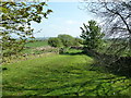
Footpath between Haslingden Old Road and Stanhill Road at Warcock Green Farm
Image: © Alexander P Kapp
Taken: 21 May 2012
0.17 miles
5
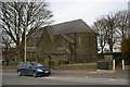
The Parish Church of St Oswald, Knuzden
Image: © Alexander P Kapp
Taken: 23 Mar 2006
0.22 miles
6
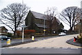
St Oswald's Church, Knuzden
This is on the beginning of Stanhill Road which leads to Oswaldtwistle and Accrington.
Image: © Bill Boaden
Taken: 12 Jan 2011
0.22 miles
9
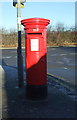
Elizabeth II postbox on Blackburn Road
Postbox No. BB1 171.
See Image] for context.
Image: © JThomas
Taken: 26 Nov 2016
0.24 miles