IMAGES TAKEN NEAR TO
Delph Close, BLACKBURN, BB1 2BL
Introduction
This page details the photographs taken nearby to Delph Close, BB1 2BL by members of the Geograph project.
The Geograph project started in 2005 with the aim of publishing, organising and preserving representative images for every square kilometre of Great Britain, Ireland and the Isle of Man.

There are currently over 7.5m images from over14,400 individuals and you can help contribute to the project by visiting https://www.geograph.org.uk
Image Map
Images are licensed for reuse under creativecommons.org/licenses/by-sa/2.0
Notes
- Clicking on the map will re-center to the selected point.
- The higher the marker number, the further away the image location is from the centre of the postcode.
Image Listing (37 Images Found)
Images are licensed for reuse under creativecommons.org/licenses/by-sa/2.0
Image
Details
Distance
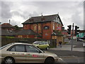
1
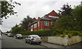
"Blackburn Evangelical Presbyterian Church" Fecitt Brow, Blackburn, Lancashire
Image: © Robert Wade
Taken: 1 Aug 2010
0.03 miles
2
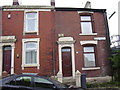
Terraced Houses, Fecitt Brow, Blackburn, Lancashire
Image: © Robert Wade
Taken: 1 Aug 2010
0.04 miles
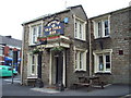
3
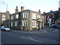
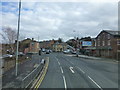
The Old Toll Bar, Accrington Road, Blackburn
Image: © Alexander P Kapp
Taken: 18 Feb 2008
0.05 miles
4
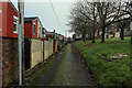
Cobbled Track off Fecitt Brow
Parallel to Accrington Road
Image: © Chris Heaton
Taken: 20 Jan 2019
0.05 miles
5
Old Toll Bar, Accrington Road, Blackburn
Image: © Alexander P Kapp
Taken: 25 May 2007
0.06 miles
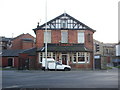
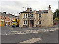
7
"The Fountain Inn" (Pub) 160 Accrington Road, Blackburn, BB1 2AH
Due to be demolished
Image: © Robert Wade
Taken: 1 Aug 2010
0.06 miles
8
The Fountain, 160 Accrington Road, Blackburn
Image: © Alexander P Kapp
Taken: 18 Feb 2008
0.07 miles
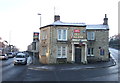
10
Old Toll Bar
The Old Toll Bar at the junction of Accrington Road (A679) with Fecitt Brow
Image: © David Dixon
Taken: 20 Jul 2011
0.07 miles