IMAGES TAKEN NEAR TO
Lane Top, BURNLEY, BB12 9QR
Introduction
This page details the photographs taken nearby to Lane Top, BB12 9QR by members of the Geograph project.
The Geograph project started in 2005 with the aim of publishing, organising and preserving representative images for every square kilometre of Great Britain, Ireland and the Isle of Man.

There are currently over 7.5m images from over14,400 individuals and you can help contribute to the project by visiting https://www.geograph.org.uk
Image Map
Images are licensed for reuse under creativecommons.org/licenses/by-sa/2.0
Notes
- Clicking on the map will re-center to the selected point.
- The higher the marker number, the further away the image location is from the centre of the postcode.
Image Listing (19 Images Found)
Images are licensed for reuse under creativecommons.org/licenses/by-sa/2.0
Image
Details
Distance
1
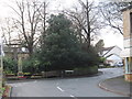
Wheatley Lane Road, Fence
Looking southwest towards the War Memorial.
Image: © Peter Wood
Taken: 15 Dec 2012
0.03 miles
2
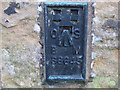
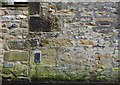
Ordnance Survey Flush Bracket S8645
This can be found on a building in Cuckstool Lane.
For more detail see : http://www.bench-marks.org.uk/bm21249
Image: © Peter Wood
Taken: 15 Dec 2012
0.03 miles
3
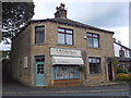
"K Melling Studio Gallery" 486 Wheatley Lane Road, Fence, Burnley, Lancashire BB12 9EB
Image: © Robert Wade
Taken: 23 Aug 2011
0.04 miles
4
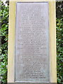
Fence War Memorial, Fence, Lancashire (Plaque Detail)
Image: © Robert Wade
Taken: 23 Aug 2011
0.05 miles
5
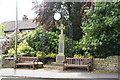
Fence War Memorial
At the junction of Cuckstool Lane and Wheatley Lane Road.
Image: © Bill Boaden
Taken: 4 Jun 2011
0.06 miles
6
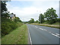
Barrowford Road (A6068)
Heading north east towards Nelson.
Image: © JThomas
Taken: 16 Jul 2016
0.08 miles
8
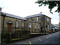
Wheatley Lane Methodist (Aided) Primary School
Image: © Alexander P Kapp
Taken: 8 May 2007
0.10 miles
9
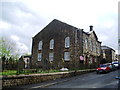
Wheatley Lane Methodist Church, Fence
Image: © Alexander P Kapp
Taken: 8 May 2007
0.12 miles
10
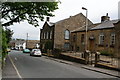
Wheatley Lane Methodist Church and School
Image: © Bill Boaden
Taken: 4 Jun 2011
0.14 miles