IMAGES TAKEN NEAR TO
Cartmel Drive, BURNLEY, BB12 8UX
Introduction
This page details the photographs taken nearby to Cartmel Drive, BB12 8UX by members of the Geograph project.
The Geograph project started in 2005 with the aim of publishing, organising and preserving representative images for every square kilometre of Great Britain, Ireland and the Isle of Man.

There are currently over 7.5m images from over14,400 individuals and you can help contribute to the project by visiting https://www.geograph.org.uk
Image Map
Images are licensed for reuse under creativecommons.org/licenses/by-sa/2.0
Notes
- Clicking on the map will re-center to the selected point.
- The higher the marker number, the further away the image location is from the centre of the postcode.
Image Listing (15 Images Found)
Images are licensed for reuse under creativecommons.org/licenses/by-sa/2.0
Image
Details
Distance
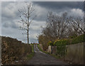
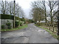
3
Access Lane to Top o' th' Close
Access track adopted by the Bronte Way long distance footpath.
Image: © Chris Heaton
Taken: 4 Mar 2017
0.11 miles
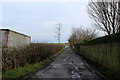
4
Puddly gateway near Top o'th' Close
Normally you can see the Rigg of England and Pendle from here.
Image: © Bill Boaden
Taken: 20 Nov 2011
0.11 miles
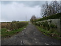
6
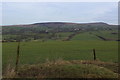
A View towards Pendle Hill
View looking northwards from the access lane to Top o' th' Close Farm
Image: © Chris Heaton
Taken: 4 Mar 2017
0.12 miles
8
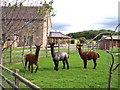
Friendly Llamas at Top o' th' Close Farm
Image: © Raymond Knapman
Taken: 10 Sep 2012
0.14 miles
9
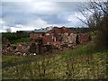
This pile of rubble is the remains of two houses.
Image: © Alexander P Kapp
Taken: 7 Apr 2008
0.16 miles
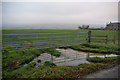
10
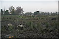
Pigs in the mud near Habergham
Seen from the Bronte Way.
Image: © Bill Boaden
Taken: 20 Nov 2011
0.17 miles