IMAGES TAKEN NEAR TO
Burnley Road, BURNLEY, BB12 8BS
Introduction
This page details the photographs taken nearby to Burnley Road, BB12 8BS by members of the Geograph project.
The Geograph project started in 2005 with the aim of publishing, organising and preserving representative images for every square kilometre of Great Britain, Ireland and the Isle of Man.

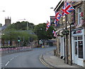
There are currently over 7.5m images from over14,400 individuals and you can help contribute to the project by visiting https://www.geograph.org.uk
Image Map
Images are licensed for reuse under creativecommons.org/licenses/by-sa/2.0
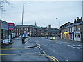
Notes
- Clicking on the map will re-center to the selected point.
- The higher the marker number, the further away the image location is from the centre of the postcode.
Image Listing (266 Images Found)
Images are licensed for reuse under creativecommons.org/licenses/by-sa/2.0
Image
Details
Distance
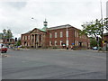
1
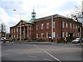
Padiham Town Hall
Padiham Town Hall on Burnley Road, built in 1938, is a Grade II listed building.
Image: © David Dixon
Taken: 12 Apr 2012
0.01 miles
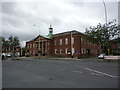
2
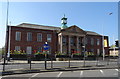
Padiham Town Hall
Built in 1938 and Grade II listed.
Image: © JThomas
Taken: 19 Apr 2019
0.01 miles
5
Burnley Road, Padiham
The church with the tower in the background is St Leonards
Image: © Alexander P Kapp
Taken: 15 Jan 2008
0.02 miles
6
Burnley Road in Padiham
The tower of St Leonard's Church in the distance.
Image: © Mat Fascione
Taken: 27 Jun 2016
0.02 miles
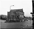
7
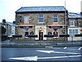
Flying Dutchman, Burnley Road, Padiham
Image: © Alexander P Kapp
Taken: 15 Jan 2008
0.02 miles
8
Padiham : Burnley Road
Looking along Burnley Road.
Image: © Lewis Clarke
Taken: 27 Sep 2019
0.02 miles
9
Burnley Road, Padiham
Looking south east, towards Burnley.
Image: © Dr Neil Clifton
Taken: 27 Oct 1987
0.02 miles
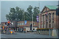
10
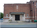
Side entrance to Council offices, Padiham
Image: © Alexander P Kapp
Taken: 21 Sep 2011
0.02 miles