IMAGES TAKEN NEAR TO
Shuttleworth Mead, Blackburn Road, BURNLEY, BB12 7SN

Introduction

This page details the photographs taken nearby to Shuttleworth Mead, Blackburn Road, BB12 7SN by members of the Geograph project.

The Geograph project started in 2005 with the aim of publishing, organising and preserving representative images for every square kilometre of Great Britain, Ireland and the Isle of Man.

There are currently over 7.5m images from over14,400 individuals and you can help contribute to the project by visiting https://www.geograph.org.uk

Image Map


Images are licensed for reuse under creativecommons.org/licenses/by-sa/2.0
Notes
  • Clicking on the map will re-center to the selected point.
  • The higher the marker number, the further away the image location is from the centre of the postcode.

Image Listing (22 Images Found)

Images are licensed for reuse under creativecommons.org/licenses/by-sa/2.0
  • ...
Image
Details
Distance
1
Electricity sub station
The only thing left of Padiham Power Station which closed in 1993, the sub station has been enlarged as well since then.
Image: © Alexander P Kapp Taken: 23 Mar 2011
0.11 miles
2
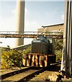
Padiham Power Station
Padiham Power Station was closed in 1993 and subsequently demolished. Here a locomotive is working on the site. It was used for shunting coal wagons. The locomotive was not named 'Barclay'; this is in fact the makers' plate, the loco having been built by Andrew Barclay of Kilmarnock, well known for constructing locomotives (principally steam) for industrial users.
Image: © Gerald England Taken: 13 Sep 1986
0.13 miles
3
Gate
This gate was in the perimeter of Padiham Power Station
Image: © Alexander P Kapp Taken: 26 Aug 2010
0.15 miles
4
Footpath on former railway
The stone work is all what remains of a bridge over the railway
Image: © Alexander P Kapp Taken: 26 Aug 2010
0.15 miles
5
Weir on the River Calder
South of Shuttleworth Business Park
Image: © Alexander P Kapp Taken: 23 Mar 2011
0.16 miles
6
Weir on the River Calder near Padiham
Image: © John Slater Taken: 15 Jun 2015
0.16 miles
7
Burnley Way above the River Calder
Image: © Chris Heaton Taken: 27 Apr 2014
0.18 miles
8
River Calder
Taken from the old railway Bridge near Park Road
Image: © Alexander P Kapp Taken: 26 Aug 2010
0.19 miles
9
Disused railway
In fact it is only about 50m long, it is all what remains of the railway which was used to bring coal the Padiham Power Station, which has long gone (1980s?)
Image: © Alexander P Kapp Taken: 26 Aug 2010
0.19 miles
10
River Calder West of Padiham
Seen here from the Burnley Way long distance footpath opposite an industrial estate - located on the site of the former Padiham Power Station, which closed in 1993.
Image: © Chris Heaton Taken: 27 Apr 2014
0.20 miles
  • ...