IMAGES TAKEN NEAR TO
Adamson Street, BURNLEY, BB12 6RB
Introduction
This page details the photographs taken nearby to Adamson Street, BB12 6RB by members of the Geograph project.
The Geograph project started in 2005 with the aim of publishing, organising and preserving representative images for every square kilometre of Great Britain, Ireland and the Isle of Man.

There are currently over 7.5m images from over14,400 individuals and you can help contribute to the project by visiting https://www.geograph.org.uk
Image Map
Images are licensed for reuse under creativecommons.org/licenses/by-sa/2.0
Notes
- Clicking on the map will re-center to the selected point.
- The higher the marker number, the further away the image location is from the centre of the postcode.
Image Listing (111 Images Found)
Images are licensed for reuse under creativecommons.org/licenses/by-sa/2.0
Image
Details
Distance
1
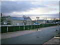
New housing "STOPPED" because of the credit crunch
Image: © Alexander P Kapp
Taken: 1 Dec 2008
0.03 miles
8
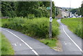
Path leading to the west towpath of the Leeds and Liverpool Canal
The path on the left is linking the east and west towpaths of the Leeds and Liverpool Canal, avoiding the Gannow Tunnel.
Image: © Mat Fascione
Taken: 27 Jun 2016
0.08 miles
9
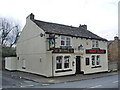
The Grey Mare, Gannow Lane, Burnley
Image: © Alexander P Kapp
Taken: 8 Apr 2008
0.09 miles