IMAGES TAKEN NEAR TO
Burnley Road, BURNLEY, BB11 5QT
Introduction
This page details the photographs taken nearby to Burnley Road, BB11 5QT by members of the Geograph project.
The Geograph project started in 2005 with the aim of publishing, organising and preserving representative images for every square kilometre of Great Britain, Ireland and the Isle of Man.

There are currently over 7.5m images from over14,400 individuals and you can help contribute to the project by visiting https://www.geograph.org.uk
Image Map
Images are licensed for reuse under creativecommons.org/licenses/by-sa/2.0
Notes
- Clicking on the map will re-center to the selected point.
- The higher the marker number, the further away the image location is from the centre of the postcode.
Image Listing (11 Images Found)
Images are licensed for reuse under creativecommons.org/licenses/by-sa/2.0
Image
Details
Distance
1

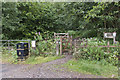
Part of a smallholding near Hapton
There was no name at the road, but boards advertising eggs and various kinds of vegetables.
Image: © Bill Boaden
Taken: 12 Jan 2011
0.04 miles
3
Burnley Road, Hapton
Looking west towards Accrington
Image: © Alexander P Kapp
Taken: 4 Dec 2009
0.07 miles
5
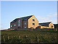
New house south side of the A679 south of Hapton
Image: © Alexander P Kapp
Taken: 4 Dec 2009
0.12 miles
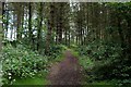
6

Two sorts of wood in Hameldon Wood
This is a coniferous part, but beyond the derelict wall they are all broad-leaved trees. The floor is different too, here being grass but beyond the wall fallen leaves.
Image: © Bill Boaden
Taken: 12 Jan 2011
0.15 miles
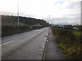
7
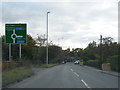
A679 Burnley Road nears the A56 junction
Image: © Colin Pyle
Taken: 21 Oct 2019
0.18 miles
8
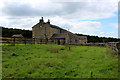
Miste Farm
Passed by on the Burnley Way long distance footpath
Image: © Chris Heaton
Taken: 5 Sep 2018
0.18 miles
9
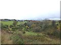
Autumn at Childers Green
View from Burley Way
Image: © Raymond Knapman
Taken: 18 Nov 2013
0.20 miles
10

The junction of the A679 with the A56 Accrington Bypass
This is viewed from Hameldon Wood, and you can see part of the easterly roundabout. The A56 is already on a higher level as it begins to climb up past Great Hameldon.
Image: © Bill Boaden
Taken: 12 Jan 2011
0.21 miles