IMAGES TAKEN NEAR TO
Oakeneaves Avenue, BURNLEY, BB11 5HH
Introduction
This page details the photographs taken nearby to Oakeneaves Avenue, BB11 5HH by members of the Geograph project.
The Geograph project started in 2005 with the aim of publishing, organising and preserving representative images for every square kilometre of Great Britain, Ireland and the Isle of Man.

There are currently over 7.5m images from over14,400 individuals and you can help contribute to the project by visiting https://www.geograph.org.uk
Image Map
Images are licensed for reuse under creativecommons.org/licenses/by-sa/2.0
Notes
- Clicking on the map will re-center to the selected point.
- The higher the marker number, the further away the image location is from the centre of the postcode.
Image Listing (32 Images Found)
Images are licensed for reuse under creativecommons.org/licenses/by-sa/2.0
Image
Details
Distance
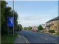
1
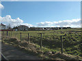
Housing Estate
Taken from layby on A646
Image: © Richard Spencer
Taken: 18 Feb 2006
0.08 miles
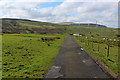
4
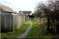
Public Footpath heading for the A682, Manchester Road
Image: © Chris Heaton
Taken: 4 Mar 2017
0.12 miles
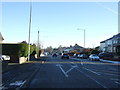
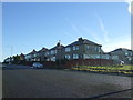
5
Escape lane on Manchester Road (A682)
Heading downhill into Burnley.
Image: © JThomas
Taken: 25 Sep 2018
0.13 miles
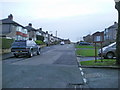
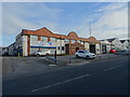
8
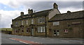
The Bull Manchester Road
Was the Bull and Butcher then the Hanging Calf. Ashoka have taken over the building to the right as an "Indian"
Image: © Robert Wade
Taken: 26 Jun 2007
0.13 miles
9
Summit Works
Collection of business units on Manchester Road, Burnley.
Image: © JThomas
Taken: 25 Sep 2018
0.14 miles
10
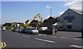
Demolition following a fire at Summit Works, Manchester Road
Image: © Robert Wade
Taken: 17 Jun 2010
0.15 miles