IMAGES TAKEN NEAR TO
Inglehurst Road, BURNLEY, BB11 5DY
Introduction
This page details the photographs taken nearby to Inglehurst Road, BB11 5DY by members of the Geograph project.
The Geograph project started in 2005 with the aim of publishing, organising and preserving representative images for every square kilometre of Great Britain, Ireland and the Isle of Man.

There are currently over 7.5m images from over14,400 individuals and you can help contribute to the project by visiting https://www.geograph.org.uk
Image Map
Images are licensed for reuse under creativecommons.org/licenses/by-sa/2.0
Notes
- Clicking on the map will re-center to the selected point.
- The higher the marker number, the further away the image location is from the centre of the postcode.
Image Listing (46 Images Found)
Images are licensed for reuse under creativecommons.org/licenses/by-sa/2.0
Image
Details
Distance
3
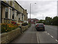
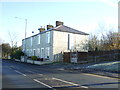
Housing, Accrington Road, Burnley
Looking towards the Rosegrove junction
Image: © Robert Wade
Taken: 12 Aug 2009
0.08 miles
4
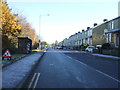
Bus stop and shelter on Accrington Road (A679)
Image: © JThomas
Taken: 26 Nov 2016
0.11 miles
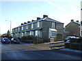
5
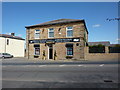
Former public house on Rossendale Road
Image: © Alexander P Kapp
Taken: 21 Apr 2010
0.11 miles
6
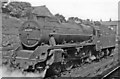
Modified Stanier LMS Class Five 4-6-0 at Rose Grove, 1951
No. 44697, built 11/50 with Timken roller-bearings, paired with a self-weighing tender, survived until 11/67; view towards Burnley.
Image: © Ben Brooksbank
Taken: 25 Jul 1951
0.13 miles
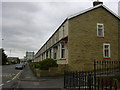
7
Burnley Cemetery, Gate Lodge
The stone lodge was built originally as the registrar's house as part of the 1923 extension to the cemetery. It is now used as cemetery offices.
Image: © David Dixon
Taken: 20 Mar 2015
0.14 miles
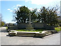
8
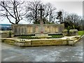
Burnley Cemetery War Memorial
The War Memorial in Burnley Cemetery stands close to the Rossendale Road entrance. Created in 1924, it includes a screen wall which records the names of 174 servicemen buried in the cemetery between 1914 and 1924. The memorial also incorporates an Imperial War Graves Commission Cross of Sacrifice. The cemetery also contains 93 scattered burials of the Second World War.
http://www.ww1cemeteries.com/othercemeteries/burnleycemmemorialwall.htm WWI Cemeteries for details of the names.
Image: © David Dixon
Taken: 20 Mar 2015
0.14 miles