IMAGES TAKEN NEAR TO
Redgate Close, BURNLEY, BB11 3EG
Introduction
This page details the photographs taken nearby to Redgate Close, BB11 3EG by members of the Geograph project.
The Geograph project started in 2005 with the aim of publishing, organising and preserving representative images for every square kilometre of Great Britain, Ireland and the Isle of Man.

There are currently over 7.5m images from over14,400 individuals and you can help contribute to the project by visiting https://www.geograph.org.uk
Image Map
Images are licensed for reuse under creativecommons.org/licenses/by-sa/2.0
Notes
- Clicking on the map will re-center to the selected point.
- The higher the marker number, the further away the image location is from the centre of the postcode.
Image Listing (47 Images Found)
Images are licensed for reuse under creativecommons.org/licenses/by-sa/2.0
Image
Details
Distance
1
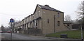
"The Cherry Tree Restaurant" 197 Todmorden Road, Burnley BB11 3EA
Image: © Robert Wade
Taken: 19 May 2011
0.10 miles
2
Towneley Golf Club, Burnley, Lancashire, England BB11 3ED
Image: © Robert Wade
Taken: 19 May 2011
0.10 miles
4
Towneley Golf Club, Burnley, Lancashire, England BB11 3ED
Image: © Robert Wade
Taken: 19 May 2011
0.14 miles
5
Brooklands Road, Burnley
Now a "Dead End" as the access has been blocked off at the Todmorden Road end
Image: © Robert Wade
Taken: 29 Mar 2011
0.15 miles
6
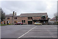
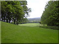
Towneley Golf Club
Club House off Todmorden Road, the course was designed by Burnley council and opened in 1932
Image: © Kevin Rushton
Taken: 27 Jan 2008
0.15 miles
7
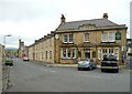
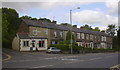
The Woodman Hotel, Burnley
Strategically placed on a wide junction on Todmorden Road, but with two other pubs nearby. The church down the road is flying the England flag, probably for election day rather than the forthcoming World Cup.
Image: © Humphrey Bolton
Taken: 6 May 2010
0.17 miles
8
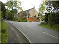
Road junction
Junction of Mayfield Fold with Rock Lane
Image: © Alexander P Kapp
Taken: 7 Oct 2009
0.17 miles
9
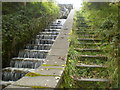
Wet and dry steps
Footpath and stream off Rock Lane
Image: © Alexander P Kapp
Taken: 7 Oct 2009
0.17 miles
10
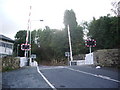
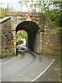
Level crossing on Hufling Lane
The railway line goes from Burnley to Todmorden
Image: © Alexander P Kapp
Taken: 3 Oct 2008
0.17 miles