IMAGES TAKEN NEAR TO
Hart Street, BURNLEY, BB11 2SG
Introduction
This page details the photographs taken nearby to Hart Street, BB11 2SG by members of the Geograph project.
The Geograph project started in 2005 with the aim of publishing, organising and preserving representative images for every square kilometre of Great Britain, Ireland and the Isle of Man.

There are currently over 7.5m images from over14,400 individuals and you can help contribute to the project by visiting https://www.geograph.org.uk
Image Map
Images are licensed for reuse under creativecommons.org/licenses/by-sa/2.0
Notes
- Clicking on the map will re-center to the selected point.
- The higher the marker number, the further away the image location is from the centre of the postcode.
Image Listing (201 Images Found)
Images are licensed for reuse under creativecommons.org/licenses/by-sa/2.0
Image
Details
Distance
3
Houses next to the Leeds and Liverpool Canal in Burnley
Image: © Mat Fascione
Taken: 27 Jun 2016
0.03 miles

9
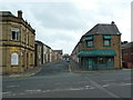
It's called a square but it is a triangle
Brown Square, Burnley
Image: © Alexander P Kapp
Taken: 28 May 2012
0.06 miles
10
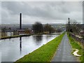
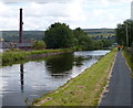
Leeds and Liverpool Canal, Burnley
The Burnley Embankment, known locally as "The Straight Mile", carries The Leeds and Liverpool Canal 60ft above the town.
When the canal was being built here at the end of the eighteenth century, Robert Whitworth, the Leeds and Liverpool Canal Company Engineer decided that an embankment, almost a mile long and up to sixty feet high, straight to the opposite hillside should be built rather than having the canal take a long detour following the contours around the valley, Although it was costly to construct, it meant the valley could be traversed by the canal without the need for two systems of locks.
The embankment was constructed between 1796 and 1801, by an army of navvies using spoil brought by boat from the canal cutting to the north of Burnley and some of the excavations from the construction of the nearby Gannow Tunnel. Heavy clay was used to line the bed of the canal to stop the water leaking out. Nowadays, concrete would be used.
The embankment, an innovative solution to the problems of canal engineering in its time, remains an impressive construction today. It is widely regarded as one of the "seven wonders" of the British Waterway System http://www.luphen.org.uk/canals/7wonders.htm .
Image: © David Dixon
Taken: 20 Mar 2015
0.06 miles