IMAGES TAKEN NEAR TO
Boot Way, BURNLEY, BB11 2EE

Introduction

This page details the photographs taken nearby to Boot Way, BB11 2EE by members of the Geograph project.

The Geograph project started in 2005 with the aim of publishing, organising and preserving representative images for every square kilometre of Great Britain, Ireland and the Isle of Man.

There are currently over 7.5m images from over14,400 individuals and you can help contribute to the project by visiting https://www.geograph.org.uk

Image Map


Images are licensed for reuse under creativecommons.org/licenses/by-sa/2.0
Notes
  • Clicking on the map will re-center to the selected point.
  • The higher the marker number, the further away the image location is from the centre of the postcode.

Image Listing (291 Images Found)

Images are licensed for reuse under creativecommons.org/licenses/by-sa/2.0
  • ...
Image
Details
Distance
1
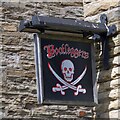
Bootleggers' sign
Sign for the Bootleggers Image
Image: © Gerald England Taken: 6 Aug 2022
0.00 miles
2
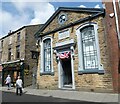
Bootleggers and Roy's Jewellers
The Grade II listed https://historicengland.org.uk/listing/the-list/list-entry/1022632?section=official-list-entry Jireh Baptist Chapel on Boot Way dates from 1853. it was built by the Strict and Particular Baptists or Gadsbyites, a sect founded in this area. Now it has been turned into a music bar called Bootleggers Image Next door is a jewellery shop.
Image: © Gerald England Taken: 6 Aug 2022
0.00 miles
3
Former Jireh Baptist Chapel
Now the Bootleggers public house
Image: © Alexander P Kapp Taken: 7 Jan 2010
0.01 miles
4
Burnley Bus Station, Lancashire
The buses serving this station are mostly as seen here, Burnley and Pendle Transport local services. But trans-Pennine services to Halifax and Keighley, and even some long-distance coach services, also start from here.
Image: © Dr Neil Clifton Taken: 26 Jul 1993
0.02 miles
5
Contact Burnley, 9 Parker Lane
This used to be The Abbey, now council offices
Image: © Robert Wade Taken: 22 May 2009
0.02 miles
6
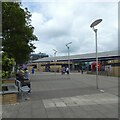
Entrance to Burnley Bus Station
Image: © Gerald England Taken: 6 Aug 2022
0.02 miles
7
St. James's Street, Burnley, Lancashire
This pedestrianised street provides a pleasant environment for the shopper, who is not deprived of liquid refreshment! The 'Red Lion' is on the extreme right, with the 'Swan' right next door to it, and, should these two not satisfy, there is 'Yates' Wine Lodge' at the end of the street.
Image: © Dr Neil Clifton Taken: 25 May 2007
0.02 miles
8
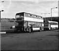
Burnley bus station
Burnley & Pendle double-decker No 166 has been painted in the livery of the former Colne Corporation Light Railways, (whose services ended in 1935).
Image: © Dr Neil Clifton Taken: 30 Sep 1984
0.02 miles
9
Burnley Bus Station
Image: © Robert Wade Taken: 22 May 2009
0.03 miles
10
Burnley Bus Station
Image: © Robert Wade Taken: 22 May 2009
0.03 miles
  • ...