IMAGES TAKEN NEAR TO
BB11 1TL
Introduction
This page details the photographs taken nearby to BB11 1TL by members of the Geograph project.
The Geograph project started in 2005 with the aim of publishing, organising and preserving representative images for every square kilometre of Great Britain, Ireland and the Isle of Man.

There are currently over 7.5m images from over14,400 individuals and you can help contribute to the project by visiting https://www.geograph.org.uk
Image Map
Images are licensed for reuse under creativecommons.org/licenses/by-sa/2.0
Notes
- Clicking on the map will re-center to the selected point.
- The higher the marker number, the further away the image location is from the centre of the postcode.
Image Listing (307 Images Found)
Images are licensed for reuse under creativecommons.org/licenses/by-sa/2.0
Image
Details
Distance
1
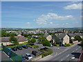
View of Burnley from Raglan Road footbridge
Looking north east
Image: © Alexander P Kapp
Taken: 30 Jun 2010
0.03 miles
3
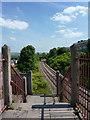
Railway, looking east from Raglan Road footbridge
Image: © Alexander P Kapp
Taken: 30 Jun 2010
0.04 miles
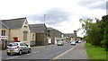
4
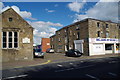
Gateway to the rear of Albert Mill, Trafalgar Street, Burnley
Image: © Alexander P Kapp
Taken: 22 Aug 2012
0.05 miles
6
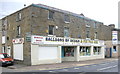
Balloons by Design Balloons, Albert Works, 35 Trafalgar Street, Burnley
Image: © Robert Wade
Taken: 8 Jul 2009
0.05 miles
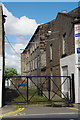
8
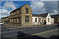
Former Habergham Eaves Parochial School, Burnley
Image: © Alexander P Kapp
Taken: 22 Aug 2012
0.06 miles
9
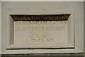
Former Habergham Eaves Parochial School, Burnley, Datestone
Image: © Alexander P Kapp
Taken: 22 Aug 2012
0.06 miles
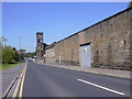
10
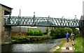
Footbridge over Leeds/Liverpool Canal - Weavers' Triangle
Image: © Betty Longbottom
Taken: 16 Aug 2007
0.06 miles