IMAGES TAKEN NEAR TO
Hurstwood Avenue, BURNLEY, BB10 4JZ
Introduction
This page details the photographs taken nearby to Hurstwood Avenue, BB10 4JZ by members of the Geograph project.
The Geograph project started in 2005 with the aim of publishing, organising and preserving representative images for every square kilometre of Great Britain, Ireland and the Isle of Man.

There are currently over 7.5m images from over14,400 individuals and you can help contribute to the project by visiting https://www.geograph.org.uk
Image Map
Images are licensed for reuse under creativecommons.org/licenses/by-sa/2.0
Notes
- Clicking on the map will re-center to the selected point.
- The higher the marker number, the further away the image location is from the centre of the postcode.
Image Listing (33 Images Found)
Images are licensed for reuse under creativecommons.org/licenses/by-sa/2.0
Image
Details
Distance
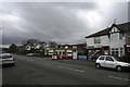
1
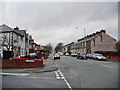
Brunshaw Road, Burnley
Looking down Brunshaw Road from its junction with Rimington Avenue
Image: © Alexander P Kapp
Taken: 4 Feb 2008
0.04 miles
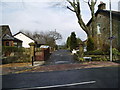
3
Brunshaw Road
Entrance to Rowley hall and lake
Image: © Kevin Rushton
Taken: 31 Jan 2008
0.06 miles
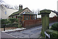
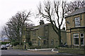
4
Brunshaw Road
Gateway and lodge to Rowley hall at the top of Rowley Lane
Image: © Kevin Rushton
Taken: 31 Jan 2008
0.07 miles
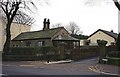
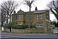
7
Brunshaw Road
Top of Brunshaw Road, Ridge Avenue to the left the house is Ivy mount at no's 374 and 376
Image: © Kevin Rushton
Taken: 31 Jan 2008
0.09 miles
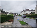
9
Brunshaw Road
Top of Rimington Avenue looking towards Pike Hill
Image: © Kevin Rushton
Taken: 31 Jan 2008
0.09 miles
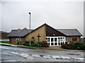
10
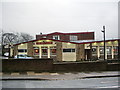
The Brunshaw, Brunshaw Road, Burnley
Image: © Alexander P Kapp
Taken: 4 Feb 2008
0.09 miles