IMAGES TAKEN NEAR TO
Thirlmere Road, BURNLEY, BB10 4HT
Introduction
This page details the photographs taken nearby to Thirlmere Road, BB10 4HT by members of the Geograph project.
The Geograph project started in 2005 with the aim of publishing, organising and preserving representative images for every square kilometre of Great Britain, Ireland and the Isle of Man.

There are currently over 7.5m images from over14,400 individuals and you can help contribute to the project by visiting https://www.geograph.org.uk
Image Map
Images are licensed for reuse under creativecommons.org/licenses/by-sa/2.0
Notes
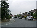
- Clicking on the map will re-center to the selected point.
- The higher the marker number, the further away the image location is from the centre of the postcode.
Image Listing (55 Images Found)
Images are licensed for reuse under creativecommons.org/licenses/by-sa/2.0
Image
Details
Distance
3
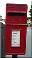
Elizabeth II postbox on Brunshaw Road. Burnley
Postbox No. BB10 81.
See Image] for postbox.
Image: © JThomas
Taken: 16 Jul 2016
0.06 miles
4
Close up, Elizabeth II postbox on Brunshaw Road, Pike Hill. Burnley
Postbox No. BB10 81.
See Image] for context.
Image: © JThomas
Taken: 16 Jul 2016
0.06 miles
8
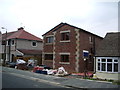
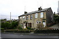
Brunshaw Road
Lodge House, this house was a former lodge for towneley Hall that also linked it to Hollins Hall
Image: © Kevin Rushton
Taken: 10 Feb 2008
0.12 miles
9
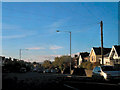
Pike Hill
Brownside Road looking towards the Thornton Arms
Image: © Kevin Rushton
Taken: 23 Mar 2008
0.13 miles
10
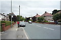
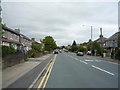
Pike Hill Brunshaw Road
The Spar shop on the left of the road was former Pike Hill Garage and filling station
Image: © Kevin Rushton
Taken: 23 Mar 2008
0.13 miles