IMAGES TAKEN NEAR TO
Olympia Street, BURNLEY, BB10 4EW
Introduction
This page details the photographs taken nearby to Olympia Street, BB10 4EW by members of the Geograph project.
The Geograph project started in 2005 with the aim of publishing, organising and preserving representative images for every square kilometre of Great Britain, Ireland and the Isle of Man.

There are currently over 7.5m images from over14,400 individuals and you can help contribute to the project by visiting https://www.geograph.org.uk
Image Map
Images are licensed for reuse under creativecommons.org/licenses/by-sa/2.0
Notes
- Clicking on the map will re-center to the selected point.
- The higher the marker number, the further away the image location is from the centre of the postcode.
Image Listing (53 Images Found)
Images are licensed for reuse under creativecommons.org/licenses/by-sa/2.0
Image
Details
Distance
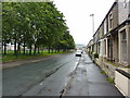
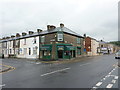
2
Athletic Street, Burnley
In the next unit along is Lancashire Sports Repairs which provides a mending service for numerous shops in the South East Lancashire area.
Image: © Bill Boaden
Taken: 11 Nov 2011
0.05 miles
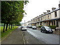
4
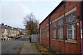
Athletic Street, Burnley
Mostly residential with terraced housing, but it has some industrial units too.
Image: © Bill Boaden
Taken: 11 Nov 2011
0.07 miles
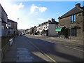
8

Lebanon Street
Looking south from Brunshaw Road.
Image: © JThomas
Taken: 16 Jul 2016
0.09 miles
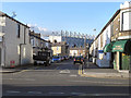
9

Burnley rooftops
This was taken from the David Fishwick Stand at Turf Moor, looking through the south east corner of the stadium.
Image: © Bill Boaden
Taken: 28 Mar 2010
0.10 miles