IMAGES TAKEN NEAR TO
Linden Street, BURNLEY, BB10 4EQ
Introduction
This page details the photographs taken nearby to Linden Street, BB10 4EQ by members of the Geograph project.
The Geograph project started in 2005 with the aim of publishing, organising and preserving representative images for every square kilometre of Great Britain, Ireland and the Isle of Man.

There are currently over 7.5m images from over14,400 individuals and you can help contribute to the project by visiting https://www.geograph.org.uk
Image Map
Images are licensed for reuse under creativecommons.org/licenses/by-sa/2.0
Notes
- Clicking on the map will re-center to the selected point.
- The higher the marker number, the further away the image location is from the centre of the postcode.
Image Listing (107 Images Found)
Images are licensed for reuse under creativecommons.org/licenses/by-sa/2.0
Image
Details
Distance
1
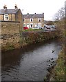
The River Calder in Burnley
Seen from the Todmorden Road bridge.
Image: © Neil Theasby
Taken: 8 Nov 2014
0.04 miles
2
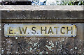
WWII Lancashire: Ghost Signs of the Home Front (23)
-
Emergency Water Supply, Hand Bridge, Todmorden Road, Burnley
"EWS Hatch"
Image
Image: © Mike Searle
Taken: 13 Aug 2021
0.04 miles
3
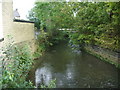
River Calder
Looking E from Hand Bridge Todmorden Road
Image: © Alexander P Kapp
Taken: 6 Oct 2008
0.05 miles
4
WWII Lancashire: Ghost Signs of the Home Front (22)
-
Emergency Water Supply, Hand Bridge, Todmorden Road, Burnley
"EWS Hatch"
A rare EWS sign of metal on the bridge over the River Calder. "EWS Hatch" may refer to a facility to obtain an emergency supply of water from the river (below the bridge).
Image
Image: © Mike Searle
Taken: 13 Aug 2021
0.05 miles
5
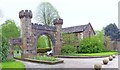
Formerly the entrance to Townley Hall and Park
This was the entrance to the Hall until Lyall Street was redeveloped into the present day entrance, it is still used but only by pedestrians
Image: © Alexander P Kapp
Taken: 6 Oct 2008
0.06 miles
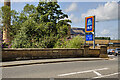
7
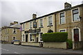
Foresters Arms, 49 Todmorden Rd, Burnley, Lancashire
Image: © Robert Wade
Taken: 22 May 2009
0.07 miles
9
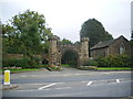
Entrance to Towneley Hall
This gateway marks the entrance to the Towneley Estate. The gatehouse next to it carries the date 1856. In practice the gateway is no longer in use with the vehicle entrance on the far side. For a view of Towneley Hall refer to picture Image
Image: © Len Williams
Taken: 22 May 2015
0.08 miles
10
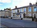
The Foresters Arms
Public house on Todmorden Road, Burnley.
Image: © David Dixon
Taken: 7 Oct 2010
0.08 miles