IMAGES TAKEN NEAR TO
Belvedere Road, BURNLEY, BB10 4BQ
Introduction
This page details the photographs taken nearby to Belvedere Road, BB10 4BQ by members of the Geograph project.
The Geograph project started in 2005 with the aim of publishing, organising and preserving representative images for every square kilometre of Great Britain, Ireland and the Isle of Man.

There are currently over 7.5m images from over14,400 individuals and you can help contribute to the project by visiting https://www.geograph.org.uk
Image Map
Images are licensed for reuse under creativecommons.org/licenses/by-sa/2.0
Notes
- Clicking on the map will re-center to the selected point.
- The higher the marker number, the further away the image location is from the centre of the postcode.
Image Listing (126 Images Found)
Images are licensed for reuse under creativecommons.org/licenses/by-sa/2.0
Image
Details
Distance
1
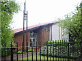
Christ Church of Latter Day Saints, Burnley
Image: © Alexander P Kapp
Taken: 8 May 2007
0.02 miles
5
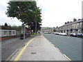
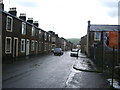
Bus stop and shelter on Belvedere Road, Burnley
Image: © JThomas
Taken: 16 Jul 2016
0.06 miles
6
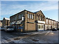
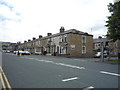
Former Branch No18 of Burnley Co-op, Thurston Street, Burnley
Image: © Alexander P Kapp
Taken: 6 Dec 2010
0.06 miles
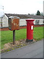
7
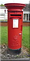
Elizabeth II postbox on Belvedere Road, Burnley
Postbox No. BB10 64.
See Image] for context.
Image: © JThomas
Taken: 16 Jul 2016
0.07 miles
8
Elizabeth II postbox on Belvedere Road, Burnley
Postbox No. BB10 64.
See Image] for close up.
Image: © JThomas
Taken: 16 Jul 2016
0.07 miles
9
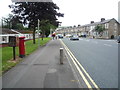
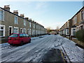
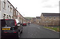
Belvedere Road, Burnley
Looking south showing position of Postbox No. BB10 64.
See Image] for postbox.
Image: © JThomas
Taken: 16 Jul 2016
0.07 miles