IMAGES TAKEN NEAR TO
Halifax Road, BURNLEY, BB10 3RS
Introduction
This page details the photographs taken nearby to Halifax Road, BB10 3RS by members of the Geograph project.
The Geograph project started in 2005 with the aim of publishing, organising and preserving representative images for every square kilometre of Great Britain, Ireland and the Isle of Man.

There are currently over 7.5m images from over14,400 individuals and you can help contribute to the project by visiting https://www.geograph.org.uk
Image Map
Images are licensed for reuse under creativecommons.org/licenses/by-sa/2.0
Notes
- Clicking on the map will re-center to the selected point.
- The higher the marker number, the further away the image location is from the centre of the postcode.
Image Listing (31 Images Found)
Images are licensed for reuse under creativecommons.org/licenses/by-sa/2.0
Image
Details
Distance
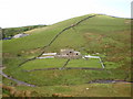
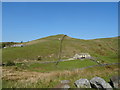
3
Farm above New Bridge
New Bridge is bottom left and crosses Thursden Brook.
Image: © Bill Boaden
Taken: 17 Dec 2010
0.03 miles
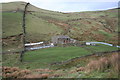
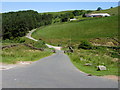
8
New Bridge End
At Thursden seen from the Slack to Colne road
Image: © Kevin Waterhouse
Taken: 26 Mar 2024
0.09 miles
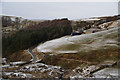
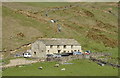
9
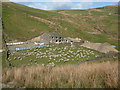
Let's have a meeting at New Bridge End
Sheep gathered for lambing
Image: © Alexander P Kapp
Taken: 20 Apr 2010
0.09 miles
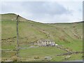
10
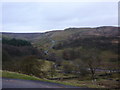
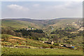
View of Thursden Valley from Broad Bank
Image: © Alexander P Kapp
Taken: 14 Dec 2010
0.10 miles