IMAGES TAKEN NEAR TO
Catlow Row, BURNLEY, BB10 3RL
Introduction
This page details the photographs taken nearby to Catlow Row, BB10 3RL by members of the Geograph project.
The Geograph project started in 2005 with the aim of publishing, organising and preserving representative images for every square kilometre of Great Britain, Ireland and the Isle of Man.

There are currently over 7.5m images from over14,400 individuals and you can help contribute to the project by visiting https://www.geograph.org.uk
Image Map
Images are licensed for reuse under creativecommons.org/licenses/by-sa/2.0
Notes
- Clicking on the map will re-center to the selected point.
- The higher the marker number, the further away the image location is from the centre of the postcode.
Image Listing (33 Images Found)
Images are licensed for reuse under creativecommons.org/licenses/by-sa/2.0
Image
Details
Distance
1
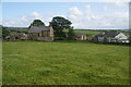
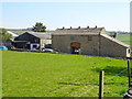
Catlow
A collection of two farms and a few cottages.
Image: © Bill Boaden
Taken: 16 Jun 2011
0.02 miles
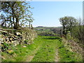
2
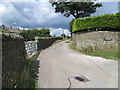
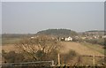
Track used by a footpath to Nelson at Catlow
Looking north-westward.
Image: © Peter Wood
Taken: 8 Aug 2018
0.02 miles
3
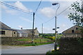
Which way to go in Catlow?
Several footpaths meet in this hamlet.
Image: © Bill Boaden
Taken: 16 Jun 2011
0.03 miles
4
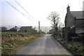
Southfield Lane
Catlow farm buildings, Catlow House to the right
Image: © Kevin Rushton
Taken: 20 Feb 2008
0.03 miles
6
Robin House Lane
Catlow farm buildings
Image: © Kevin Rushton
Taken: 20 Feb 2008
0.04 miles
7
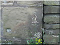
Ordnance Survey Cut Mark
This mark can be found on a building at Gyll Farm.
For more detail see : http://www.bench-marks.org.uk/bm45233
Image: © Peter Wood
Taken: 5 Sep 2012
0.04 miles
10
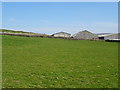
Field entrance off Southfield Lane, Catlow
Image: © JThomas
Taken: 19 Apr 2019
0.07 miles