IMAGES TAKEN NEAR TO
Halifax Road, BURNLEY, BB10 3QS
Introduction
This page details the photographs taken nearby to Halifax Road, BB10 3QS by members of the Geograph project.
The Geograph project started in 2005 with the aim of publishing, organising and preserving representative images for every square kilometre of Great Britain, Ireland and the Isle of Man.

There are currently over 7.5m images from over14,400 individuals and you can help contribute to the project by visiting https://www.geograph.org.uk
Image Map
Images are licensed for reuse under creativecommons.org/licenses/by-sa/2.0
Notes
- Clicking on the map will re-center to the selected point.
- The higher the marker number, the further away the image location is from the centre of the postcode.
Image Listing (21 Images Found)
Images are licensed for reuse under creativecommons.org/licenses/by-sa/2.0
Image
Details
Distance
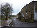
1
Minor road towards Haggate
Looking west near Hill Farm.
Image: © JThomas
Taken: 19 Apr 2019
0.02 miles
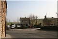
2
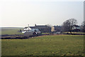
Halifax Road Lane Bottom
View of Holt Hill Farm,East Barn and West Barn from Robin House Lane
Image: © Kevin Rushton
Taken: 20 Feb 2008
0.12 miles
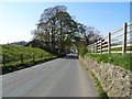
3
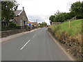
Halifax Road near Hill Lane Baptist Church at Lane Bottom
Looking eastward.
Image: © Peter Wood
Taken: 8 Aug 2018
0.13 miles
4
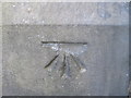
Ordnance Survey Cut Mark
This mark can be found on the Baptist Church.
For more detail see : http://www.bench-marks.org.uk/bm45232
Image: © Peter Wood
Taken: 5 Sep 2012
0.13 miles
6
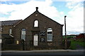
Hill Lane Baptist Church, Lane Bottom, Burnley
Image: © Alexander P Kapp
Taken: 13 Oct 2005
0.19 miles
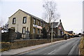
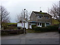
7
Lane Bottom
Police Station on Halifax Road
Image: © Kevin Rushton
Taken: 20 Feb 2008
0.20 miles
8
Briercliffe Police Station, Lane Bottom
Image: © Alexander P Kapp
Taken: 14 Dec 2010
0.21 miles