IMAGES TAKEN NEAR TO
Todmorden Road, BURNLEY, BB10 3PJ
Introduction
This page details the photographs taken nearby to Todmorden Road, BB10 3PJ by members of the Geograph project.
The Geograph project started in 2005 with the aim of publishing, organising and preserving representative images for every square kilometre of Great Britain, Ireland and the Isle of Man.

There are currently over 7.5m images from over14,400 individuals and you can help contribute to the project by visiting https://www.geograph.org.uk
Image Map
Images are licensed for reuse under creativecommons.org/licenses/by-sa/2.0
Notes
- Clicking on the map will re-center to the selected point.
- The higher the marker number, the further away the image location is from the centre of the postcode.
Image Listing (19 Images Found)
Images are licensed for reuse under creativecommons.org/licenses/by-sa/2.0
Image
Details
Distance
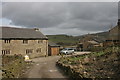
1
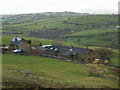
Elders I' th' Row
The group of farmhouses to the right are Elders Farmhouse, Bren Rose Barn, Molrenhead Barn, Elders Barn and Pike Lowe Barn
Image: © Kevin Rushton
Taken: 7 Feb 2009
0.01 miles
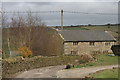
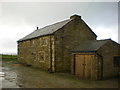
2
Monk Hall
The Hall was used as a Work House in the 1820's
Image: © Kevin Rushton
Taken: 15 Mar 2009
0.10 miles
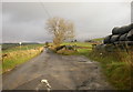
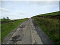
4
Track off the road to Sweet Well House
Image: © Alexander P Kapp
Taken: 20 Apr 2010
0.11 miles
5
Track off the road to Sweet Well House
Image: © Alexander P Kapp
Taken: 23 Nov 2009
0.12 miles
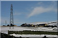
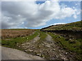
7
Access Lane on Bonfire Hill
Metalled access to dwellings and fields above Monk Hall.
Image: © Chris Heaton
Taken: 7 Oct 2009
0.13 miles
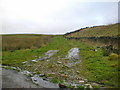
9
Monk Hall Farm
Spring on the track to Park Wood
Image: © Kevin Rushton
Taken: 15 Mar 2009
0.15 miles