IMAGES TAKEN NEAR TO
The Crescent, BURNLEY, BB10 3LX
Introduction
This page details the photographs taken nearby to The Crescent, BB10 3LX by members of the Geograph project.
The Geograph project started in 2005 with the aim of publishing, organising and preserving representative images for every square kilometre of Great Britain, Ireland and the Isle of Man.

There are currently over 7.5m images from over14,400 individuals and you can help contribute to the project by visiting https://www.geograph.org.uk
Image Map
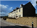
Images are licensed for reuse under creativecommons.org/licenses/by-sa/2.0
Notes
- Clicking on the map will re-center to the selected point.
- The higher the marker number, the further away the image location is from the centre of the postcode.
Image Listing (50 Images Found)
Images are licensed for reuse under creativecommons.org/licenses/by-sa/2.0
Image
Details
Distance
1
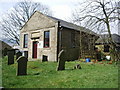
Former Wesleyan Church, Worsthorne
Now used as a children's nursery
Image: © Alexander P Kapp
Taken: 11 Apr 2008
0.01 miles
2
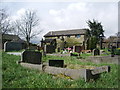
Former Wesleyan Church, Worsthorne, Graveyard
Image: © Alexander P Kapp
Taken: 11 Apr 2008
0.02 miles
3
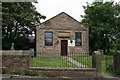
Day Nursery, Worsthorne, Lancashire
Former Wesleyan Methodist Sunday School building.
Image: © Dr Neil Clifton
Taken: 8 Sep 2007
0.05 miles
4
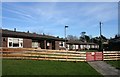
Meadowside, Worsthorne
A small development, with a fantastic view
Image: © Alexander P Kapp
Taken: 19 Sep 2012
0.05 miles
5
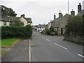
Brownside Road, Worsthorne
Approaching the centre of Worsthorne on Brownside Road.
Image: © Chris Heaton
Taken: 7 Oct 2009
0.05 miles
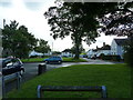
6
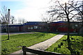
Worsthorne Village
Worsthorne County Primary School Brownside Road
Image: © Kevin Rushton
Taken: 10 Feb 2008
0.05 miles
7
Worsthorne Village
Retirement homes for the elderly
Image: © Kevin Rushton
Taken: 10 Feb 2008
0.06 miles
8
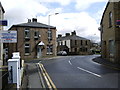
Road junction
Junction of Lennox Street and Brownside Road
Image: © Alexander P Kapp
Taken: 11 Apr 2008
0.06 miles