IMAGES TAKEN NEAR TO
Mount Pleasant, BURNLEY, BB10 3LU
Introduction
This page details the photographs taken nearby to Mount Pleasant, BB10 3LU by members of the Geograph project.
The Geograph project started in 2005 with the aim of publishing, organising and preserving representative images for every square kilometre of Great Britain, Ireland and the Isle of Man.

There are currently over 7.5m images from over14,400 individuals and you can help contribute to the project by visiting https://www.geograph.org.uk
Image Map
Images are licensed for reuse under creativecommons.org/licenses/by-sa/2.0
Notes
- Clicking on the map will re-center to the selected point.
- The higher the marker number, the further away the image location is from the centre of the postcode.
Image Listing (51 Images Found)
Images are licensed for reuse under creativecommons.org/licenses/by-sa/2.0
Image
Details
Distance
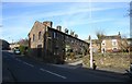
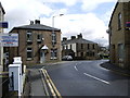
1
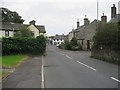
Brownside Road, Worsthorne
Approaching the centre of Worsthorne on Brownside Road.
Image: © Chris Heaton
Taken: 7 Oct 2009
0.02 miles
2
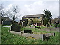
Former Wesleyan Church, Worsthorne, Graveyard
Image: © Alexander P Kapp
Taken: 11 Apr 2008
0.02 miles
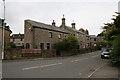
3
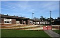
Worsthorne Village
Retirement homes for the elderly
Image: © Kevin Rushton
Taken: 10 Feb 2008
0.03 miles
4
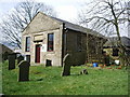
Former Wesleyan Church, Worsthorne
Now used as a children's nursery
Image: © Alexander P Kapp
Taken: 11 Apr 2008
0.03 miles

6
Worsthorne Village
The Square, the first cottage was once a newsagent's shop
Image: © Kevin Rushton
Taken: 10 Feb 2008
0.04 miles
7
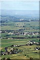
View North from Thieveley Pike
This view takes in Mereclough and Worsthorne with some red roofs of Colne beyond. Malham Cove is faintly visible, some 23 miles north
Image: © Richard Johnson
Taken: 17 Oct 1993
0.05 miles
9
Annarly Fold, Worsthorne, Lancashire
Image: © Dr Neil Clifton
Taken: 8 Sep 2007
0.05 miles
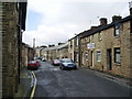
10
Road junction
Junction of Lennox Street and Brownside Road
Image: © Alexander P Kapp
Taken: 11 Apr 2008
0.05 miles