IMAGES TAKEN NEAR TO
Bancroft Road, BURNLEY, BB10 2TQ
Introduction
This page details the photographs taken nearby to Bancroft Road, BB10 2TQ by members of the Geograph project.
The Geograph project started in 2005 with the aim of publishing, organising and preserving representative images for every square kilometre of Great Britain, Ireland and the Isle of Man.

There are currently over 7.5m images from over14,400 individuals and you can help contribute to the project by visiting https://www.geograph.org.uk
Image Map
Images are licensed for reuse under creativecommons.org/licenses/by-sa/2.0
Notes
- Clicking on the map will re-center to the selected point.
- The higher the marker number, the further away the image location is from the centre of the postcode.
Image Listing (6 Images Found)
Images are licensed for reuse under creativecommons.org/licenses/by-sa/2.0
Image
Details
Distance
2
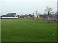
Heasandford The Burnley Way
The pathway follows the canal which carried water from the lodge to Heasandford Mill
Image: © Kevin Rushton
Taken: 5 Mar 2006
0.19 miles
3

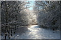
Path remedial works in the Brun Valley Forest Park
The broad paths are kept in good order by the local councils.
Image: © Bill Boaden
Taken: 12 Jan 2022
0.20 miles
4
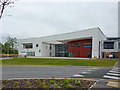
Sir John Thursby School, Burnley
One of the many schools in Burnley which have been rebuilt over the last few years
Image: © Alexander P Kapp
Taken: 26 May 2010
0.20 miles
6

Woodland in Scrogg's Wood
Part of the Brun Valley Forest Park. The land slopes down to the River Don, which is just about seen ahead.
Image: © Bill Boaden
Taken: 12 Jan 2022
0.25 miles