IMAGES TAKEN NEAR TO
Balderstone Lane, BURNLEY, BB10 2SA
Introduction
This page details the photographs taken nearby to Balderstone Lane, BB10 2SA by members of the Geograph project.
The Geograph project started in 2005 with the aim of publishing, organising and preserving representative images for every square kilometre of Great Britain, Ireland and the Isle of Man.

There are currently over 7.5m images from over14,400 individuals and you can help contribute to the project by visiting https://www.geograph.org.uk
Image Map
Images are licensed for reuse under creativecommons.org/licenses/by-sa/2.0
Notes
- Clicking on the map will re-center to the selected point.
- The higher the marker number, the further away the image location is from the centre of the postcode.
Image Listing (11 Images Found)
Images are licensed for reuse under creativecommons.org/licenses/by-sa/2.0
Image
Details
Distance
1
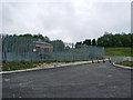
New building on Widow Hill Industrial Estate
Image: © Alexander P Kapp
Taken: 3 Jun 2008
0.09 miles
2
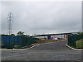
New building on Widow Hill Industrial Estate
Image: © Alexander P Kapp
Taken: 3 Jun 2008
0.10 miles
4
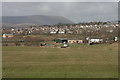
Musty Haulgh Farm Buildings
View Towards Harle Syke
Image: © Kevin Rushton
Taken: 15 Mar 2009
0.15 miles
5

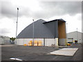
Council depot in Heasandford
A base for Lancashire County Council gritting lorries.
Image: © Bill Boaden
Taken: 12 Jan 2022
0.19 miles
6

Widow Hill Road
A winding road through Heasandford Industrial Estate.
Image: © Bill Boaden
Taken: 12 Jan 2022
0.20 miles
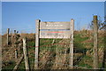
7
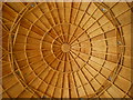
What is it you may ask?
Well see the link http://www.geograph.org.uk/photo/1294051
Image: © Alexander P Kapp
Taken: 8 May 2009
0.21 miles
8
Salt dome, Heasandford Industrial Estate
Road salt is stored in these types of buildings because the salt is treated with molasses which improves the lasting qualities when the salt is spread on the roads and has to be kept in a dry place. For a photo of the interior see link http://www.geograph.org.uk/photo/1294048
Image: © Alexander P Kapp
Taken: 8 May 2009
0.21 miles
9
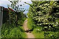
Footpath leading towards Widow Hill Road
Sandwiched between the railings of industrial compounds, this path leads away from the woods above the River Don to Widow Hill Road.
Image: © Chris Heaton
Taken: 2 Jun 2016
0.21 miles
10
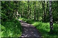
Path through Woods above the River Don
Image: © Chris Heaton
Taken: 2 Jun 2016
0.22 miles