IMAGES TAKEN NEAR TO
Hodder Street, BURNLEY, BB10 2QD
Introduction
This page details the photographs taken nearby to Hodder Street, BB10 2QD by members of the Geograph project.
The Geograph project started in 2005 with the aim of publishing, organising and preserving representative images for every square kilometre of Great Britain, Ireland and the Isle of Man.

There are currently over 7.5m images from over14,400 individuals and you can help contribute to the project by visiting https://www.geograph.org.uk
Image Map
Images are licensed for reuse under creativecommons.org/licenses/by-sa/2.0
Notes
- Clicking on the map will re-center to the selected point.
- The higher the marker number, the further away the image location is from the centre of the postcode.
Image Listing (39 Images Found)
Images are licensed for reuse under creativecommons.org/licenses/by-sa/2.0
Image
Details
Distance
1

Thames Avenue, Burnley
Off Casterton Avenue.
Image: © JThomas
Taken: 16 Jul 2016
0.08 miles
2
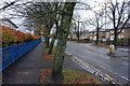
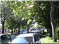
Casterton Avenue
A mainly residential road used as a bit of a ring road round the eastern side of Burnley.
Image: © Bill Boaden
Taken: 18 Nov 2015
0.09 miles
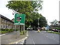
3

Casterton Avenue (A6114)
Looking south east.
Image: © JThomas
Taken: 16 Jul 2016
0.11 miles
5
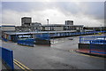
Burnley General Hospital
Not really the most scenic of hospitals. This is the front aspect as seen from Casterton Avenue.
Image: © Bill Boaden
Taken: 18 Nov 2015
0.12 miles
6
Casterton Avenue (A6114), Burnley
Heading south east.
Image: © JThomas
Taken: 16 Jul 2016
0.12 miles
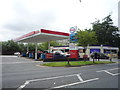
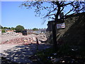
9

Road works on Marsden Road, Burnley
Image: © Alexander P Kapp
Taken: 3 Oct 2008
0.13 miles
10
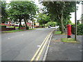
Casterton Avenue
Showing position of Postbox No. BB10 169.
See Image] for postbox.
Image: © JThomas
Taken: 16 Jul 2016
0.13 miles