IMAGES TAKEN NEAR TO
Sandiway Drive, BURNLEY, BB10 2JS
Introduction
This page details the photographs taken nearby to Sandiway Drive, BB10 2JS by members of the Geograph project.
The Geograph project started in 2005 with the aim of publishing, organising and preserving representative images for every square kilometre of Great Britain, Ireland and the Isle of Man.

There are currently over 7.5m images from over14,400 individuals and you can help contribute to the project by visiting https://www.geograph.org.uk
Image Map
Images are licensed for reuse under creativecommons.org/licenses/by-sa/2.0
Notes
- Clicking on the map will re-center to the selected point.
- The higher the marker number, the further away the image location is from the centre of the postcode.
Image Listing (30 Images Found)
Images are licensed for reuse under creativecommons.org/licenses/by-sa/2.0
Image
Details
Distance
3
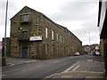
Drainpipes, Siberia Mill, Harle Syke
Image: © Alexander P Kapp
Taken: 1 Sep 2006
0.13 miles
4
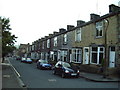
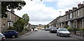
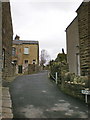
Terrace Houses, in Holgate Street, Harle Syke
Image: © Alexander P Kapp
Taken: 1 Sep 2006
0.13 miles
7
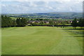
A fairway at Nelson Golf Club
The Pendle Way crosses two fairways. Here the views extend over Burnley.
Image: © Bill Boaden
Taken: 16 Jun 2011
0.13 miles
8
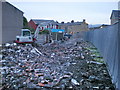
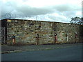
Demolition site near Milton Street
Image: © Alexander P Kapp
Taken: 14 Jan 2009
0.15 miles
10
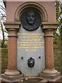
Memorial drinking fountain, (Detail)
http://www.geograph.org.uk/photo/1228352
Image: © Alexander P Kapp
Taken: 30 Mar 2009
0.18 miles