IMAGES TAKEN NEAR TO
Hillingdon Road, BURNLEY, BB10 2EG
Introduction
This page details the photographs taken nearby to Hillingdon Road, BB10 2EG by members of the Geograph project.
The Geograph project started in 2005 with the aim of publishing, organising and preserving representative images for every square kilometre of Great Britain, Ireland and the Isle of Man.

There are currently over 7.5m images from over14,400 individuals and you can help contribute to the project by visiting https://www.geograph.org.uk
Image Map (Loading...)


Getting Data...Please wait
Leaflet Map data © OpenStreetMap
Images are licensed for reuse under creativecommons.org/licenses/by-sa/2.0
Notes
- Clicking on the map will re-center to the selected point.
- The higher the marker number, the further away the image location is from the centre of the postcode.
Image Listing (18 Images Found)
Images are licensed for reuse under creativecommons.org/licenses/by-sa/2.0
Image
Details
Distance
2
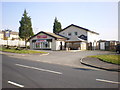
The Hillingdon Arms, Islington Close, Burnley
This pub has changed its name from The Lane Head
Image: © Alexander P Kapp
Taken: 3 Jun 2008
0.16 miles
3
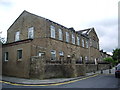
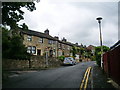
Former National School on Marsden Road, Burnley
Image: © Alexander P Kapp
Taken: 18 Jun 2008
0.16 miles
5
The Hillingdon Arms, Islington Close
Image: © Alexander P Kapp
Taken: 20 Mar 2009
0.17 miles
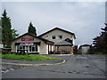
7
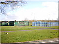
Learning Centre off Islington Close
Image: © Alexander P Kapp
Taken: 23 Mar 2009
0.17 miles
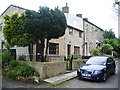
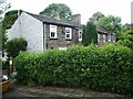
10
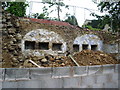
What are these?
There were four cottages on the Ordnance Survey large scale map (1880)? could they be the remains of the cottages larders.
Image: © Alexander P Kapp
Taken: 18 Jun 2008
0.19 miles