IMAGES TAKEN NEAR TO
St. Andrews Street, BURNLEY, BB10 1RH
Introduction
This page details the photographs taken nearby to St. Andrews Street, BB10 1RH by members of the Geograph project.
The Geograph project started in 2005 with the aim of publishing, organising and preserving representative images for every square kilometre of Great Britain, Ireland and the Isle of Man.

There are currently over 7.5m images from over14,400 individuals and you can help contribute to the project by visiting https://www.geograph.org.uk
Image Map
Images are licensed for reuse under creativecommons.org/licenses/by-sa/2.0
Notes
- Clicking on the map will re-center to the selected point.
- The higher the marker number, the further away the image location is from the centre of the postcode.
Image Listing (61 Images Found)
Images are licensed for reuse under creativecommons.org/licenses/by-sa/2.0
Image
Details
Distance
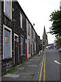
1
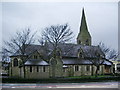
The Parish Church of St Andrew with St Margaret & St James, Burnley
Image: © Alexander P Kapp
Taken: 4 Feb 2008
0.04 miles
2
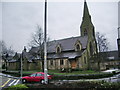
The Parish Church of St Andrew with St Margaret & St James, Burnley
Image: © Alexander P Kapp
Taken: 4 Feb 2008
0.05 miles
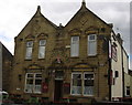
6
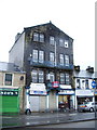
St Andrews Conservative Club, Colne Road, Burnley
Image: © Alexander P Kapp
Taken: 4 Feb 2008
0.07 miles
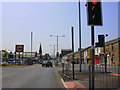
7
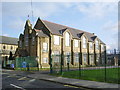
St Johns RC Primary School, Burnley
Image: © Alexander P Kapp
Taken: 1 Oct 2008
0.08 miles
9
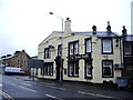
The Derby Arms, Colne Road, Burnley
Image: © Alexander P Kapp
Taken: 4 Feb 2008
0.08 miles
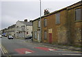
10
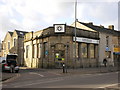
Former Burnley Building Society office
Now used by the St John's Ambulance
Image: © Alexander P Kapp
Taken: 23 Mar 2009
0.09 miles