IMAGES TAKEN NEAR TO
Old Hall Street, BURNLEY, BB10 1DA
Introduction
This page details the photographs taken nearby to Old Hall Street, BB10 1DA by members of the Geograph project.
The Geograph project started in 2005 with the aim of publishing, organising and preserving representative images for every square kilometre of Great Britain, Ireland and the Isle of Man.

There are currently over 7.5m images from over14,400 individuals and you can help contribute to the project by visiting https://www.geograph.org.uk
Image Map (Loading...)


Getting Data...Please wait
Leaflet Map data © OpenStreetMap
Images are licensed for reuse under creativecommons.org/licenses/by-sa/2.0
Notes
- Clicking on the map will re-center to the selected point.
- The higher the marker number, the further away the image location is from the centre of the postcode.
Image Listing (125 Images Found)
Images are licensed for reuse under creativecommons.org/licenses/by-sa/2.0
Image
Details
Distance
1
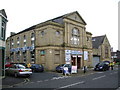
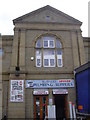
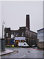
Former Chapel on Old hall Street, Burnley
Image: © Alexander P Kapp
Taken: 17 Sep 2008
0.02 miles
2
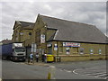
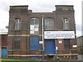
Burnley Plumbing Supplies Hanover Chapel Old Hall Street Burnley
Image: © Robert Wade
Taken: 8 Jul 2009
0.03 miles
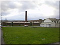
8
Crown Cabinets, Head Office, Unit 1a, Elm St Mill, Elm St, Burnley
Image: © Robert Wade
Taken: 8 Jul 2009
0.06 miles