IMAGES TAKEN NEAR TO
Pen Selwood, WINCANTON, BA9 8LL
Introduction
This page details the photographs taken nearby to BA9 8LL by members of the Geograph project.
The Geograph project started in 2005 with the aim of publishing, organising and preserving representative images for every square kilometre of Great Britain, Ireland and the Isle of Man.

There are currently over 7.5m images from over14,400 individuals and you can help contribute to the project by visiting https://www.geograph.org.uk
Image Map (Loading...)


Getting Data...Please wait
Leaflet Map data © OpenStreetMap
Images are licensed for reuse under creativecommons.org/licenses/by-sa/2.0
Notes
- Clicking on the map will re-center to the selected point.
- The higher the marker number, the further away the image location is from the centre of the postcode.
Image Listing (19 Images Found)
Images are licensed for reuse under creativecommons.org/licenses/by-sa/2.0
Image
Details
Distance
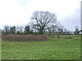
1

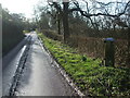
Penselwood : Underhill
Looking along the country lane.
Image: © Lewis Clarke
Taken: 20 Mar 2023
0.03 miles
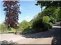
2
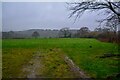
Penselwood : Grassy Field
A right of way heads through the field.
Image: © Lewis Clarke
Taken: 20 Mar 2023
0.04 miles
3
Penselwood pump
This covered box houses the original water pump for the village of Penselwood, albeit that the water is some 500m south of the houses. See Image] for a closer look.
Image: © Neil Owen
Taken: 4 Feb 2020
0.06 miles
4

Penselwood's water pump
Now encased in an oak box, the pump has been here for well over a century. A plaque records its restoration during the Queen's Silver Jubilee in 1977. See Image] for a wider view.
Image: © Neil Owen
Taken: 4 Feb 2020
0.06 miles
5
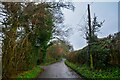
Penselwood : Underhill
Looking along the country lane.
Image: © Lewis Clarke
Taken: 20 Mar 2023
0.11 miles
6
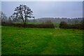
Penselwood : Grassy Field
Following the right of way through the field.
Image: © Lewis Clarke
Taken: 20 Mar 2023
0.12 miles
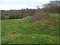
7
Ballands Castle
This earthwork near Penselwood is the remains of a Norman motte and bailey castle. This (southern) end was marked on OS maps of about the early 1900s as the site of a church, with tumuli to the north. Neither have been substantiated these days.
Image: © Neil Owen
Taken: 4 Feb 2020
0.14 miles
8
South west flank of Ballands Castle
The old Norman motte and bailey earthworks near Penselwood is one of three such remains in the general area. There is evidence of structures in Cockroad Wood to the north and also overlooking the River Stour near Zeals Row to the north east.
Image: © Neil Owen
Taken: 4 Feb 2020
0.15 miles
10
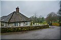
Penselwood : Forest Lodge Cottage
Alongside the track heading to Forest Lodge is this Grade II listed building.
Image: © Lewis Clarke
Taken: 20 Mar 2023
0.18 miles