IMAGES TAKEN NEAR TO
Shepton Montague, WINCANTON, BA9 8JH
Introduction
This page details the photographs taken nearby to BA9 8JH by members of the Geograph project.
The Geograph project started in 2005 with the aim of publishing, organising and preserving representative images for every square kilometre of Great Britain, Ireland and the Isle of Man.

There are currently over 7.5m images from over14,400 individuals and you can help contribute to the project by visiting https://www.geograph.org.uk
Image Map
Images are licensed for reuse under creativecommons.org/licenses/by-sa/2.0
Notes
- Clicking on the map will re-center to the selected point.
- The higher the marker number, the further away the image location is from the centre of the postcode.
Image Listing (11 Images Found)
Images are licensed for reuse under creativecommons.org/licenses/by-sa/2.0
Image
Details
Distance

3
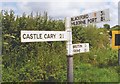
Old Direction Sign - Signpost by Cattle Hill, Shepston Montague parish
Finial lost since 2009 - 3 arms; Somerset SCC pyramid by the UC road, in parish of Shepton Montague (South Somerset District), Caryedge Lane junction with Cattle Hill.
Surveyed
Milestone Society National ID: SO_ST6731A
Image: © Milestone Society
Taken: Unknown
0.14 miles
6
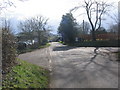
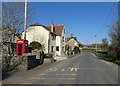
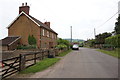
Shepton Montague
A view looking south to the crossroads at the northern end of the village of Shepton Montague.
Image: © Phil Williams
Taken: 5 Mar 2006
0.17 miles
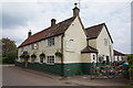
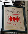
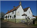
10
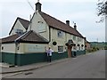
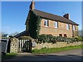
The Montague Inn, Shepton Montague
Award winning food pub.
Image: © Steve Barnes
Taken: 1 May 2011
0.18 miles