IMAGES TAKEN NEAR TO
Charlton Musgrove, WINCANTON, BA9 8HN
Introduction
This page details the photographs taken nearby to BA9 8HN by members of the Geograph project.
The Geograph project started in 2005 with the aim of publishing, organising and preserving representative images for every square kilometre of Great Britain, Ireland and the Isle of Man.

There are currently over 7.5m images from over14,400 individuals and you can help contribute to the project by visiting https://www.geograph.org.uk
Image Map
Images are licensed for reuse under creativecommons.org/licenses/by-sa/2.0
Notes
- Clicking on the map will re-center to the selected point.
- The higher the marker number, the further away the image location is from the centre of the postcode.
Image Listing (8 Images Found)
Images are licensed for reuse under creativecommons.org/licenses/by-sa/2.0
Image
Details
Distance
1
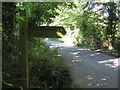
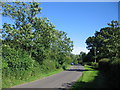
Barrow Lane
A view looking east along Barrow Lane opposite the bridleway to Pen Hill.
Image: © Phil Williams
Taken: 7 Jul 2007
0.03 miles
2
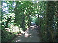
Bridleway to Pen Hill
A view looking east along the bridleway from Barrow Lane to Pen Hill.
Image: © Phil Williams
Taken: 7 Jul 2007
0.04 miles
4
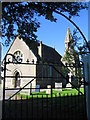
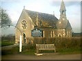
St. Johns, Charlton Musgrove
A view looking north through the gate at the entrance to St. Johns church.
Image: © Phil Williams
Taken: 7 Jul 2007
0.12 miles
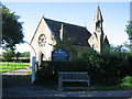
5
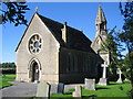
St. Johns, Charlton Musgrove
A view looking north towards St. Johns church.
Image: © Phil Williams
Taken: 7 Jul 2007
0.12 miles
7
Barrow Lane
A view looking to the southeast along Barrow Lane from the entrance to Homestead Farm.
Image: © Phil Williams
Taken: 7 Jul 2007
0.17 miles
8
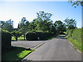
Approaching Homestead Farm
A view looking to the northwest along Barrow Lane towards the entrance to Homestead Farm.
Image: © Phil Williams
Taken: 7 Jul 2007
0.20 miles